Are you ready to take your surveying, construction, or environmental analysis to the next level? When it comes to aerial data collection for 3D mapping, DJI drones are often the first choice for professionals and hobbyists alike. Their blend of cutting-edge camera technology, stable flight performance, and user-friendly interfaces makes them incredibly popular. But with so many options, how do you pick the best DJI drone for 3D mapping?
We’ve done the legwork for you! This guide breaks down 10 excellent DJI drones, highlighting their strengths and weaknesses for various mapping needs. Whether you’re aiming for highly accurate photogrammetry, quick site inspections, or detailed terrain modeling, you’re bound to find a perfect fit. Let’s dive in and find the best DJI drone for 3D mapping that suits your projects and budget.
1. DJI Mini 4K Camera Drone Combo

The DJI Mini 4K Camera Drone Combo is an appealing entry point for anyone looking to get their feet wet with aerial photography and basic 3D mapping. While not a professional mapping tool, its compact size and high-quality 4K camera make it fantastic for small-scale projects or learning the ropes of geospatial data capture. It’s incredibly beginner-friendly, and its lightweight design means you often won’t need FAA registration, making it a hassle-free option for quick data acquisition.
Key Features:
– No Registration Needed – Under 249 g
– 4K Ultra HD & 3-Axis Gimbal for Cinematic Quality
– 38kph (Level 5) Wind Resistant
– 10km Max HD Video Transmission
– Extended Battery Life (31-93 min depending on combo)
– Beginner-Friendly with GPS Return to Home (RTH)
– Intelligent QuickShots (Helix, Dronie, Rocket, Circle, Boomerang)
Pros:
– Extremely lightweight and portable, easy to carry anywhere.
– Excellent 4K camera quality for its size and price.
– Impressive wind resistance for a mini drone, ensuring stable image capture.
– Long video transmission range allows for broader coverage.
– Multiple battery options provide flexible flight times.
– Simple to fly, great for those new to drone operation and basic mapping.
Cons:
– Lacks advanced mapping features like precise waypoint navigation or RTK/PPK.
– Not ideal for large-scale, high-accuracy 3D mapping projects.
– DJI Fly app removed from Google Play requires manual download.
User Impressions: Users love its portability and the surprisingly good image quality for such a small drone. It’s often praised as a perfect “grab and go” option for personal projects and fun, even if it’s not a mapping powerhouse.
2. DJI Mini 4K Fly More Combo

Essentially an upgraded package of the standard DJI Mini 4K, the Fly More Combo is a much smarter choice if you’re serious about getting more flight time for your mapping endeavors. The extra batteries are a game-changer, allowing you to cover larger areas or re-fly missions without having to constantly recharge. It still boasts the same excellent 4K camera and user-friendly features, making it a strong contender for those needing extended basic aerial mapping capabilities without breaking the bank.
Key Features:
– Includes DJI Mini 4K, 3 batteries, two-way charging hub, and shoulder bag.
– No Registration Needed – Under 249 g
– 4K Ultra HD & 3-Axis Gimbal for Cinematic Quality
– 38kph (Level 5) Wind Resistant
– 10km Max HD Video Transmission
– Extended Battery Life (up to 93 minutes total with 3 batteries)
– Beginner-Friendly and Safe
– Intelligent QuickShots
Pros:
– Significantly extended flight time with three batteries, crucial for longer mapping sessions.
– Two-way charging hub adds convenience for quick battery management.
– Still offers the portability and image quality of the standard Mini 4K.
– Great value for money considering the additional accessories.
Cons:
– Shares the same limitations as the standard Mini 4K regarding advanced mapping features.
– Not suitable for professional, highly accurate surveying tasks.
User Impressions: Customers frequently highlight the value of the Fly More Combo, noting that the extra batteries make a huge difference in practical use, especially for capturing comprehensive data over an area.
3. DJI Mini 3 (DJI RC)

The DJI Mini 3, especially with the DJI RC controller, elevates the “Mini” experience significantly. While still ultra-light, it brings in more advanced camera capabilities like 4K HDR video and Dual Native ISO Fusion, which are excellent for capturing details in challenging lighting – a big plus for mapping accurate visual data. Its True Vertical Shooting is a unique feature, though less critical for traditional 3D mapping, it’s great for specific visual documentation. The integrated display on the DJI RC controller is a massive convenience, allowing you to focus purely on your flight and data capture.
Key Features:
– No Registration Needed (under 249g) for recreational use.
– 4K UHD Stunning Imagery with HDR Video and Dual Native ISO Fusion.
– True Vertical Shooting for portrait-oriented content.
– Extended Battery Life (up to 51 min with Intelligent Flight Battery Plus, sold separately).
– 38kph (Level 5) Wind Resistant and 3-Axis Gimbal.
– 10km Max HD Video Transmission.
– Creative Features (QuickShots, Panorama).
– Beginner-Friendly and Safe (GPS RTH, Precise Hovering).
– QuickTransfer via Wi-Fi.
– Includes DJI RC with built-in 5.5-inch HD display.
Pros:
– Superior image quality with HDR and Dual Native ISO for better detail retention.
– Dedicated DJI RC controller improves the piloting experience and reduces setup time.
– Impressive flight time, especially with the optional Intelligent Flight Battery Plus.
– Robust wind resistance and stable gimbal for consistent data.
– QuickTransfer makes getting data off the drone a breeze.
Cons:
– Intelligent Flight Battery Plus increases weight over 249g, potentially requiring registration.
– Still lacks specific mapping-centric features like RTK/PPK or advanced mission planning.
– True Vertical Shooting is less relevant for standard 3D mapping workflows.
User Impressions: The DJI RC controller is a huge hit, making the flight experience much smoother. Users appreciate the enhanced camera for its ability to capture stunning details, making it a strong candidate for visual site inspections that feed into simpler 3D models.
4. DJI Mini 4K, Drone with 4K UHD Camera for Adults

This is the most basic package of the DJI Mini 4K, offering a single battery and the RC-N1C remote controller. If your 3D mapping tasks are infrequent, quick, or confined to very small areas, this entry-level option might suffice. It provides the same foundational camera quality and ease of use as its combo counterparts but with a more limited flight duration. It’s an affordable way to get started with basic aerial data collection and understand the workflow before investing in more advanced setups.
Key Features:
– No Registration Needed – Under 249 g
– 4K Ultra HD & 3-Axis Gimbal for Cinematic Quality
– 38kph (Level 5) Wind Resistant
– Extended Battery Life (31-min with one battery)
– Beginner-Friendly and Safe
– Intelligent QuickShots
– Includes DJI Mini 4K, 1 battery, RC-N1C remote controller.
Pros:
– Most affordable entry into the DJI Mini 4K ecosystem.
– Lightweight and portable, adhering to strict drone regulations.
– Excellent 4K camera and stable footage for its price point.
– Simple operation makes it accessible for novices in aerial photography and basic mapping.
Cons:
– Limited flight time with a single battery, making it less efficient for mapping larger areas.
– RC-N1C requires a smartphone, which can be less convenient than a built-in screen.
– Lacks the comprehensive accessories found in the Fly More Combo.
– Not suited for professional mapping due to lack of advanced features.
User Impressions: This basic Mini 4K is often recommended for those dipping their toes into drones. Users find it surprisingly capable for casual photography and short, simple aerial tasks, appreciating its ease of use and crisp video.
5. DJI Avata 2 Fly More Combo (3 Batteries)

Hold on a sec! The DJI Avata 2 is a beast, but it’s an FPV (First Person View) drone designed for immersive, adrenaline-pumping flight and capturing dynamic, cinematic footage, not traditional, precise 3D mapping. Its super-wide 155° FOV (Field of View) and intuitive motion control are geared towards unique aerial perspectives and acrobatic maneuvers. While it captures stunning 4K/60fps footage, the distorted perspective from the wide FOV and the lack of precise grid flight capabilities make it generally unsuitable for accurate photogrammetry and generating detailed 3D models. However, if your “3D mapping” involves creating visually engaging, immersive 3D walkthroughs or artistic models where precise measurements aren’t the priority, the Avata 2 offers an unparalleled experience.
Key Features:
– Unlock Adrenaline-Pumping Immersive Flying with goggles.
– Intuitive Motion Control for easy flight.
– Easy ACRO for cinematic stunts.
– Tight Shots in Super-Wide 4K (155° FOV, 1/1.3-inch sensor).
– Built-in Propeller Guard for safety.
– Hassle-Free POV Content, filmmaking at launch.
– DJI Avata 2 Fly More Combo (3 Batteries) includes drone, 3 batteries, DJI RC Motion 3, DJI Goggles 3.
– FAA Remote ID Compliant.
Pros:
– Unrivaled immersive flight experience.
– Captures incredibly dynamic and unique aerial footage.
– Robust with integrated propeller guards.
– Excellent 4K/60fps video quality for its purpose.
– Multiple batteries in the combo extend flying fun.
Cons:
– Not suitable for precise 3D mapping/photogrammetry due to extreme wide-angle lens distortion.
– Lack of traditional waypoint navigation for systematic data capture.
– Focus is on FPV piloting and cinematic shots, not geospatial data accuracy.
– FPV flying has a steeper learning curve for precise control.
User Impressions: FPV enthusiasts absolutely rave about the Avata 2’s immersive flight and cinematic capabilities. They love the feeling of being “in the cockpit” and the ability to capture jaw-dropping dynamic shots, but acknowledge it’s not for accurate surveying.
6. DJI Mini 3 Fly More Combo (DJI RC)

The DJI Mini 3 Fly More Combo with the DJI RC controller is arguably one of the best value propositions for someone who needs a highly capable and portable drone for advanced hobbyist aerial photography and initial explorations into 3D mapping. The combined benefits of the Mini 3’s enhanced camera (4K HDR, Dual Native ISO), extended flight time from the Fly More kit (up to 114 minutes total), and the convenience of the DJI RC’s integrated screen make it a very compelling package. It’s perfect for capturing comprehensive visual data for small to medium-sized areas where precision is desired but not necessarily RTK-level accuracy.
Key Features:
– No Registration Needed (under 249g) for recreational use.
– 4K UHD Stunning Imagery with HDR Video and Dual Native ISO Fusion.
– True Vertical Shooting.
– Extended Battery Life (up to 114 minutes total with Fly More combo).
– 38kph (Level 5) Wind Resistant and 3-Axis Gimbal.
– 10km Max HD Video Transmission.
– Creative Features (QuickShots, Panorama).
– Beginner-Friendly and Safe.
– QuickTransfer via Wi-Fi.
– Includes DJI Mini 3, 3 batteries, two-way charging hub, shoulder bag, and DJI RC.
Pros:
– Comprehensive package for extended flying and data capture.
– Excellent camera for capturing detailed visual information in varying light.
– DJI RC controller provides a superior and streamlined user experience.
– Long total flight time makes covering larger areas more feasible.
– Stable flight and good wind resistance ensure consistent photo quality.
Cons:
– Still lacks enterprise-level mapping features like RTK/PPK.
– While good, the camera sensor might not meet the strict requirements for highly precise professional surveying.
– Fly More combo increases upfront cost.
User Impressions: This combo frequently receives five-star ratings, with users highlighting the perfect balance of portability, camera quality, and extended flight time. It’s often seen as the ultimate package for advanced hobbyists and content creators.
7. DJI Flip (RC-N3)

The DJI Flip seems to be a new or rebranded model, likely positioning itself as another highly portable, user-friendly drone. With full-coverage propeller guards and a weight under 249g, it emphasizes safety and ease of use, making it approachable for beginners and those wanting to fly indoors or in tighter spaces. Its 1/1.3-inch CMOS sensor and 4K/60fps HDR video capabilities are impressive for its presumed class, offering excellent image fidelity for visual inspections and generating decent quality base imagery for simple 3D models. The subject tracking feature is great for dynamic content but less so for systematic mapping.
Key Features:
– Full-coverage propeller guards for safety.
– Lightweight and Regulation Friendly (under 249 g).
– Subject tracking capabilities.
– 1/1.3-inch CMOS Sensor for clearer images.
– Stunning 4K/60fps HDR Video.
– 31-Min Max Flight Time.
– Includes DJI Flip, DJI RC-N3 remote controller, one Intelligent Flight Battery.
Pros:
– Enhanced safety with integrated propeller guards.
– Excellent camera sensor and video capabilities for its size.
– Lightweight design avoids FAA registration for recreational use.
– Good flight time for a compact drone.
– Subject tracking can be useful for dynamic documentation.
Cons:
– Single battery limits total flight time for mapping.
– RC-N3 requires a smartphone, which can be less convenient.
– Lacks advanced mapping features like waypoint missions or RTK/PPK.
– “Flip” implies potentially more action-oriented design, not optimized for mapping.
User Impressions: Given its newness, specific user impressions might be limited, but based on features, it would appeal to safety-conscious beginners and those wanting robust video capture in a highly portable, protected package.
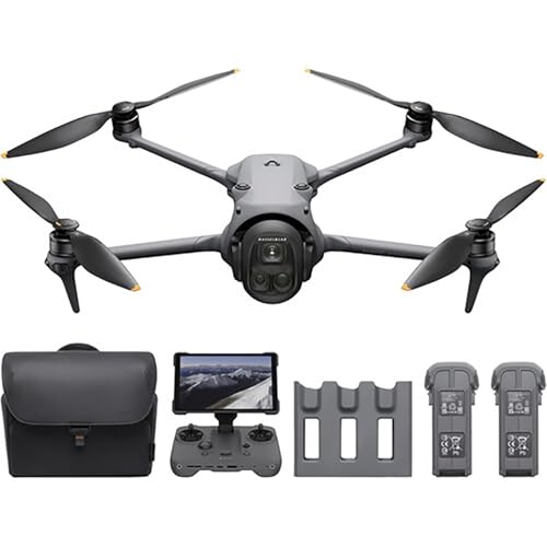
8. DJI Mavic 4 Pro Fly More Combo with DJI RC

Now we’re talking serious business for 3D mapping! The DJI Mavic 4 Pro Fly More Combo is a powerhouse, built for professionals. Its 100MP Hasselblad camera (with 6K/60fps HDR video) and versatile dual tele cameras provide an incredible level of detail and flexibility crucial for high-fidelity photogrammetry and terrain modeling. The 360° Infinity Gimbal and 0.1-Lux Nightscape Omnidirectional Obstacle Sensing significantly enhance its operational capabilities and safety. Coupled with an impressive 51-minute flight time and the professional-grade RC Pro 2 controller, this is one of the best DJI drone for 3d mapping for serious projects demanding precision and robust data collection.
Key Features:
– 100MP Hasselblad camera with 6K/60fps HDR video.
– Versatile Dual Tele Cameras for detailed zooms.
– 360° Infinity Gimbal for dynamic angles.
– 0.1-Lux Nightscape Omnidirectional Obstacle Sensing.
– Extended 51 minutes of flight time.
– Long-Range 30km/18.6mi O4+ video transmission.
– 7″ rotatable, high-bright remote controller RC Pro 2.
– Includes Mavic 4 Pro, 3 batteries, charging hub.
Pros:
– Unmatched camera quality for highly detailed 3D models and precise measurements.
– Dual tele cameras offer flexibility for various mapping scales and perspectives.
– Long flight time and advanced transmission range for extensive coverage.
– Superior obstacle sensing enhances safety during complex mapping missions.
– Professional-grade RC Pro 2 controller with a bright, large screen.
– Excellent for professional-grade photogrammetry and surveying.
Cons:
– Significant investment compared to Mini series drones.
– Larger and heavier, potentially requiring more stringent regulations.
– The 360° gimbal is overkill for standard nadir mapping, though useful for inspection.
– No explicit mention of RTK/PPK, which is often desired for centimeter-level accuracy (though potentially available in higher-tier versions or via third-party accessories).
User Impressions: Professionals consistently praise the Mavic 4 Pro series for its exceptional camera capabilities, robust build, and extended operational features. Users highlight its ability to capture incredibly detailed imagery, making it a go-to for serious mapping and inspection work.
9. DJI Mavic 4 Pro Drone 512GB Creator Combo (DJI RC Pro 2)
The DJI Mavic 4 Pro 512GB Creator Combo pushes the boundaries even further, catering specifically to creators and mappers who demand the absolute best in image quality, storage, and workflow efficiency. The 4/3 CMOS sensor with Hasselblad Natural Color Solution ensures stunning 100MP photos and 6K HDR video, making your 3D models incredibly lifelike and accurate. With 512GB of onboard storage and QuickTransfer via Wi-Fi 6, managing massive datasets is much smoother. This combo is designed for extensive, high-fidelity data acquisition, providing the tools needed for comprehensive and professional-grade 3D mapping projects where data integrity and volume are key.
Key Features:
– 100MP Hasselblad Camera (4/3 CMOS sensor, 6K/60fps HDR video).
– Dual Telephoto Cameras (1/1.3″ 48MP medium tele, 1/1.5″ 50MP tele).
– Infinity Gimbal 360° Rotation.
– 0.1-Lux Nightscape Vision & Omnidirectional Obstacle Sensing.
– 51-Minute Flight Time.
– DJI O4+ Transmission (30 km, 10-bit HDR live video).
– ActiveTrack 360° Tracking.
– 4K/120fps Slow Motion Recording.
– Up to 512GB Onboard Storage with UFS memory.
– QuickTransfer with Wi-Fi 6.
Pros:
– Top-tier camera sensor and resolution for the most detailed photogrammetry.
– Massive 512GB onboard storage is ideal for large mapping missions.
– Fast data transfer with Wi-Fi 6 streamlines post-processing workflow.
– Exceptional flight time and obstacle avoidance for reliable operations.
– Professional-grade features suitable for demanding commercial mapping applications.
– Includes the advanced DJI RC Pro 2 for superior control.
Cons:
– Premium price point makes it a significant investment.
– Larger drone requires careful flight planning and adherence to regulations.
– The advanced features might be overkill for basic mapping needs.
– Still, verify RTK/PPK availability if centimeter-level accuracy is critical.
User Impressions: This combo is the dream for high-end videographers and serious professional mappers. Users praise the unparalleled image detail, the sheer volume of data it can handle, and the efficient workflow it enables. It’s truly built for those who won’t compromise on quality.
10. DJI Neo Three-Battery Combo

The DJI Neo is an interesting entry, focusing on extreme portability and ease of use, reminiscent of a selfie drone but with surprising capabilities. Weighing just 135g, it’s incredibly regulation-friendly and fits almost anywhere. While its primary appeal is for casual vlogging and fun, its 4K Ultra-Stabilized Video with DJI stabilization technology and Level-4 wind resistance means it can capture surprisingly smooth, high-quality footage. For basic, informal “mapping” or visual documentation of small, accessible areas, especially where discretion is needed, the Neo offers a unique proposition. Its palm takeoff and landing, along with multiple control options, emphasize its user-friendliness for quick data capture.
Key Features:
– Extremely Lightweight and Regulation Friendly (135g).
– Palm Takeoff & Landing, Go Controller-Free.
– Subject Tracking & QuickShots.
– Multiple Control Options (controller-free, voice, app, RC).
– 4K Ultra-Stabilized Video with Level-4 wind resistance.
– Full-Coverage Propeller Guards.
– Extend flights to 54 minutes with the Three-Battery Combo.
– Includes DJI Neo, 3 Batteries, Two-Way Charging Hub.
Pros:
– Ultra-light and compact, making it incredibly portable and hassle-free for regulations.
– Very easy to fly with multiple intuitive control options.
– Surprisingly good 4K stabilized video for its size.
– Full-coverage propeller guards enhance safety and allow indoor flight.
– Extended flight time with three batteries makes it useful for short, repeated tasks.
Cons:
– Not designed for precise 3D mapping; lacks critical features like waypoint navigation.
– Smaller sensor likely has limitations in complex lighting compared to larger drones.
– Best suited for very small, informal mapping or visual documentation tasks.
– No mention of advanced GPS or positioning for georeferencing accuracy.
User Impressions: Users would likely love its extreme portability and ease of use for quick, spontaneous captures. It’s a fun drone that can surprisingly pull off decent video, making it suitable for casual content creation, but not for serious photogrammetry.
Frequently Asked Questions about DJI Drones and 3D Mapping
Q1: What makes a DJI drone good for 3D mapping?
A1: A good DJI drone for 3D mapping combines several key features: a high-resolution camera with a quality sensor for sharp, detailed images; a stable 3-axis gimbal to prevent blur; sufficient battery life for longer missions; reliable GPS for accurate positioning; and often, advanced flight planning capabilities (like waypoint navigation for systematic grid flights). For professional use, RTK/PPK modules for centimeter-level accuracy are highly desirable.
Q2: Do I need specialized software for 3D mapping with a DJI drone?
A2: Yes, typically you’ll need third-party photogrammetry software like Pix4D, DroneDeploy, Agisoft Metashape, or RealityCapture. These programs take the overlapping images captured by your drone, process them, and generate 3D models, orthomosaics, point clouds, and other geospatial data. Some DJI drones (especially enterprise models) integrate well with these platforms, and some even offer basic mapping tools within their own apps.
Q3: Is FAA registration required for all DJI drones used for 3D mapping?
A3: For recreational use in the US, drones weighing under 249 grams generally don’t require FAA registration or Remote ID. However, if you’re using the drone for commercial purposes (which 3D mapping often falls under, even if for personal business), you typically need to register the drone regardless of weight and obtain a Part 107 certificate. Always check the latest local aviation regulations as they can vary.
Q4: What’s the difference between the Mini series and Mavic Pro series for mapping?
A4: The Mini series (e.g., Mini 3, Mini 4K) are consumer-grade, ultra-light drones ideal for beginners, casual photography, and very basic visual documentation. They offer excellent portability and good camera quality for their size but lack advanced mapping features. The Mavic Pro series (e.g., Mavic 4 Pro) are professional-grade drones with significantly higher resolution cameras, larger sensors, longer flight times, advanced obstacle sensing, and often support for RTK/PPK modules, making them far more suitable for accurate and large-scale 3D mapping, surveying, and inspections.
Q5: What is RTK/PPK and why is it important for mapping?
A5: RTK (Real-Time Kinematic) and PPK (Post-Processed Kinematic) are advanced GPS technologies that significantly improve the positional accuracy of your drone’s image geotags. Standard GPS might give accuracy within a few meters, but RTK/PPK can reduce this to centimeter-level accuracy. This is crucial for professional 3D mapping and surveying where highly precise measurements and georeferenced models are required, reducing the need for extensive ground control points (GCPs).
Q6: How long do drone batteries typically last for mapping missions?
A6: Flight times vary greatly depending on the drone model, payload, wind conditions, and flight speed. Consumer drones like the Mini series typically offer 25-35 minutes per battery, while professional drones like the Mavic Pro series can provide 40-50+ minutes. For mapping, it’s always recommended to have multiple batteries on hand to complete missions efficiently without interruption.
Q7: Can I use FPV drones (like the DJI Avata 2) for 3D mapping?
A7: Generally, no, FPV drones like the Avata 2 are not suitable for precise 3D mapping or photogrammetry. Their super-wide-angle lenses introduce significant distortion, and their flight style is geared towards dynamic, immersive video, not systematic, nadir (downward-facing) image capture required for accurate models. They can capture unique perspectives but aren’t designed for measurable geospatial data.
Q8: Are there any specific flight planning apps recommended for DJI drones for mapping?
A8: While some DJI drones have basic waypoint features, for serious 3D mapping, many professionals use third-party apps that integrate with DJI drones. Popular choices include Pix4Dcapture, DroneDeploy, or Litchi. These apps offer more robust mission planning features like grid flight patterns, adjustable overlap, and terrain-following capabilities, which are essential for consistent and accurate data collection.
Conclusion
Choosing the best DJI drone for 3D mapping ultimately depends on your specific needs, budget, and the level of accuracy your projects demand. For beginners or those on a tight budget needing basic visual documentation, the DJI Mini 3 Fly More Combo (DJI RC) offers a fantastic balance of portability, camera quality, and extended flight time. However, if you’re a professional aiming for high-accuracy photogrammetry, large-scale terrain modeling, and robust data acquisition, the DJI Mavic 4 Pro Fly More Combo or the Mavic 4 Pro 512GB Creator Combo are clear winners, delivering unparalleled image quality and professional-grade features.
Remember, the drone is just one part of the puzzle. Investing in good mapping software and understanding photogrammetry principles will truly unlock the full potential of your aerial data. Happy mapping!


