Drone technology has absolutely revolutionized industries like construction, agriculture, surveying, and environmental monitoring. But getting truly precise and reliable data for your mapping projects isn’t just about picking any drone. To achieve the best drone for mapping results, you need more than just the aerial vehicle itself; you need a suite of sophisticated tools that enhance accuracy, streamline workflows, and ensure data integrity.
Think of it this way: a high-performance race car is great, but it needs the right tires, fuel, and navigation system to win. Similarly, your drone mapping operations demand top-tier accessories and ground support equipment to deliver professional-grade outcomes. We’ve compiled a list of 7 essential products that will supercharge your drone mapping capabilities, taking your projects to the next level of precision and efficiency. Let’s dive in!
Sky High Bull’s-Eye Drone Ground Control Point GCP – UAV (Pack 1)

When you’re aiming for millimeter-level accuracy in your drone maps, Ground Control Points (GCPs) are non-negotiable. These Sky High Bull’s-Eye GCPs are meticulously designed to be highly visible and durable, acting as critical reference points for your aerial surveys. What makes them stand out is their intelligent design, featuring a center eyelet for precise survey rod placement and matte finish material to prevent glare, ensuring your post-processing is as smooth and accurate as possible. They’re built to withstand the elements, making them perfect for repeated use in diverse environments.
-
Key Features:
- 24”x24” aerial targets for low to medium altitude drone mapping (up to 400 feet).
- Center eyelet for direct survey rod positioning and protection.
- Lightweight and durable weatherproof mesh material with matte finish to reduce glare.
- Compatible with popular photogrammetry software and auto-detection.
- Corner anchor points to prevent movement and allow long-term deployment.
- Numbered 0-9 for easy identification (expandable to 0-99).
- Quick-drying and snow-melting mesh design.
- Economical and superior to DIY GCPs.
-
Pros:
- Exceptional visibility and anti-glare properties for accurate data capture.
- Robust construction ensures longevity and repeatable accuracy.
- Numbered targets simplify field identification and post-processing.
- User-friendly features like center eyelet and corner anchors.
- Cost-effective compared to making your own.
-
Cons:
- Requires physical placement and retrieval, adding field time.
- May need additional anchoring stakes (not included).
User Impressions: Customers consistently praise these GCPs for their ruggedness and high visibility, even from significant altitudes. Many highlight how the numbered design and center eyelet significantly cut down on processing time and improve overall mapping accuracy. They’re considered a solid investment for professional drone surveyors.
Slamtec RPLIDAR M2M3 Mapping Lidar Sensor Scanner, 40Meter
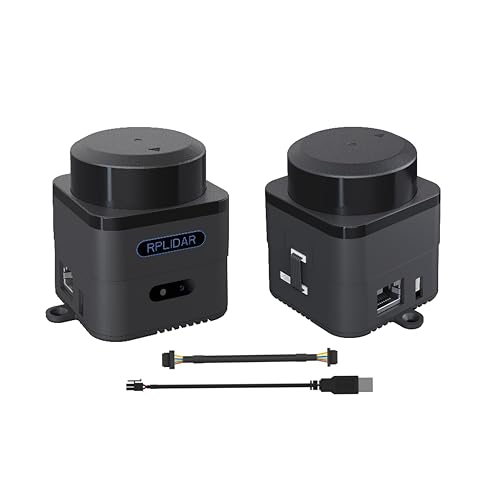
While many drone mapping solutions rely on photogrammetry, LiDAR offers a powerful alternative, especially in challenging environments with dense foliage or low light. The Slamtec RPLIDAR M2M3 sensor is a fantastic piece of kit that brings real-time 3D mapping capabilities to your projects. Its built-in SLAM (Simultaneous Localization and Mapping) technology and impressive 40-meter range allow for highly accurate environmental mapping, robot navigation, or even handheld measurement applications. This sensor is a game-changer for those needing detailed point cloud data.
-
Key Features:
- High accuracy measuring range: 0.1m – 40m with 360° angular range.
- Rotational speed: 8Hz-15Hz, Sampling Frequency: 32KHz.
- Built-in 10/100M Ethernet and WiFi (802.11a/b/g/n/ac) communication.
- Integrated SLAM real-time map building and localization.
- SLAM SharpEdge Technology for 100,000 sqm high-precision mapping.
- Built-in 9-degree-of-freedom inertial navigation system for stable data.
- Complete SDK and ROS Driver support for developers.
- Rich software including RoboStudio for graphical debugging.
-
Pros:
- Enables real-time 3D mapping, ideal for complex environments.
- High accuracy and wide range for versatile applications.
- Robust connectivity options (Ethernet, WiFi) and developer support.
- SLAM technology significantly improves efficiency and data quality.
- Can be used in various modes, including handheld, beyond just drones.
-
Cons:
- Integration with a drone platform requires technical expertise.
- LiDAR data processing can be complex and resource-intensive.
User Impressions: Developers and researchers rave about the M2M3’s performance and the comprehensive SDK support. Its ability to create precise maps in real-time, even in dynamic settings, makes it a favorite for advanced robotics and mapping applications. Users appreciate the stable data transmission and robust SLAM capabilities.
Cyiwniao 10 Pack Drone Ground Control Point GCP, Center

Another excellent option for ensuring accuracy in your aerial surveys is the Cyiwniao 10 Pack of Drone Ground Control Points. These GCPs, like their Sky High counterparts, are crucial for georeferencing your drone data, leading to precise maps and 3D models. Their clear black and white contrast ensures optimal visibility for your drone’s camera, making target detection in post-processing a breeze. The inclusion of numbers 0-9 in each pack further aids in efficient fieldwork and data management, improving the overall efficiency of your drone mapping workflows.
-
Key Features:
- 10-pack of GCPs, numbered 0-9 for easy identification.
- Strong black and white color contrast for optimal visibility.
- 24”x24” size, ideal for drone surveying and mapping tasks.
- Made of high-quality, wear-resistant, scratch-resistant, and waterproof Oxford cloth.
- Screen-printed numbers for clarity.
- Five holes (4 corner, 1 center) for secure ground fixing.
-
Pros:
- Cost-effective pack of 10 for larger projects or replacements.
- High-contrast design boosts visibility for accurate data capture.
- Durable Oxford cloth material withstands harsh outdoor conditions.
- Multiple anchor points ensure stability in windy environments.
- Numbered system simplifies field logistics.
-
Cons:
- Oxford cloth, while durable, might not be as resistant to extreme wear as specialized mesh materials over long periods.
- No anti-glare matte finish explicitly mentioned in features.
User Impressions: Users find these GCPs to be a great value, especially for their durability and clear numbering. They are highly appreciated for their ability to stay put in windy conditions due to the multiple fixing holes. Customers note that the distinct black and white pattern makes them very easy for drone cameras and software to detect.
Sky High Bull’s-Eye Drone Ground Control Point GCP – UAV (Pack 2)

This second offering from Sky High Bull’s-Eye reinforces their commitment to high-quality drone surveying accessories. Similar to the first, these GCPs are all about boosting accuracy for your best drone for mapping projects. This specific variant emphasizes its numbered targets and the classic checkerboard pattern, making them incredibly versatile and compatible with a wide array of photogrammetry software. Their lightweight yet robust design means they’re easy to transport and quick to deploy, perfect for dynamic fieldwork.
-
Key Features:
- Numbered targets (0-9) for easy identification and correlation with coordinates.
- White & black color scheme for optimal visibility and enhanced exposure in datasets.
- Four (4) corner eyelets for secure ground fixation, especially in windy conditions.
- Lightweight, durable, and waterproof material for field use.
- 24″ x 24″ checkerboard pattern, ideal size for drone mapping up to 400 feet.
-
Pros:
- Excellent visibility for clearer images and more accurate data.
- Robust anchor points provide stability and peace of mind.
- Numbered system integrates seamlessly with common mapping software.
- Durable and waterproof for long-lasting outdoor use.
- Easy to transport and set up due to lightweight design.
-
Cons:
- Like other GCPs, requires manual placement and retrieval.
- The waterproof material needs careful handling to avoid punctures over time.
User Impressions: Customers consistently highlight the clarity and accuracy these GCPs provide for their mapping data. The numbered targets are a significant time-saver in post-processing, and the secure corner eyelets are highly valued in challenging weather. They’re seen as a reliable and effective solution for professional surveyors.
E1 Lite RTK Base Station – High Accuracy GNSS GPS

For achieving true centimeter-level accuracy in your drone mapping, an RTK (Real-Time Kinematic) base station like the E1 Lite is an absolute game-changer. This device acts as a static reference point, correcting the real-time position data received by your drone’s RTK module. Without an RTK base station, your drone’s GPS data alone won’t deliver the precision needed for many professional applications. The E1 Lite stands out for its quick fixed solutions, robust build, and cost-effectiveness, making high-precision surveying accessible to a wider range of professionals.
-
Key Features:
- Centimeter-level accuracy with full-constellation GNSS support.
- Achieves fixed solutions within seconds, even in challenging environments.
- Exceptional cost-to-performance ratio.
- Versatile connectivity: NFC, Bluetooth, WiFi, USB Type-C, and 8GB storage.
- Rugged IP67 rating for dust and waterproof protection.
- Supports Base Station mode with SingularPad software (no extra license).
- Rover Mode available with a permanent SingularPad license.
-
Pros:
- Unlocks the highest level of accuracy for drone mapping projects.
- Fast signal acquisition and robust performance in difficult conditions.
- Durable, weather-resistant design for reliable outdoor use.
- Flexible connectivity options for data transfer and management.
- Makes RTK technology more affordable for professionals.
-
Cons:
- UHF function in the U.S. requires an FCC radio license for commercial use.
- Rover mode requires an additional software license, increasing overall cost.
User Impressions: Surveyors and mapping professionals are incredibly impressed with the E1 Lite’s precision and speed in achieving fixed solutions. Its robust build quality and competitive pricing make it a top choice for those looking to upgrade their accuracy without breaking the bank. The versatility in connectivity is also a major plus for field operations.
Sky High Bull’s-Eye (24″x24″) Drone Ground Control Point GCP (Pack 3)

Yet another vital tool from Sky High Bull’s-Eye, this GCP variant focuses on enhanced convenience and pre-established markers. What sets this particular GCP apart is its “center passthrough” design. This ingenious feature allows you to slide the GCP directly over existing survey stakes or markers, drastically improving efficiency. This means you can establish your control points days or weeks in advance, then simply place these GCPs precisely over them on flight day, ensuring repeatable and accurate data collection for your ongoing drone mapping projects.
-
Key Features:
- 24”x24” aerial targets, ideal for low to medium altitude drone mapping (up to 400 feet).
- Unique center passthrough design for existing survey markers.
- Lightweight and durable weatherproof mesh material with a matte finish to reduce glare.
- Compatible with popular photogrammetry software and auto-detection.
- UAV GCP with corner anchor points for stability and long-term deployment.
-
Pros:
- Center passthrough streamlines workflow by allowing pre-placement of survey markers.
- Matte finish effectively minimizes glare for clearer images.
- Durable and weatherproof material ensures longevity.
- Corner anchors prevent movement and guarantee repeatable data.
- Excellent visibility for drone cameras.
-
Cons:
- The passthrough design requires careful handling to avoid tearing if not properly aligned with stakes.
- Lacks specific numbering, which some users might prefer for field organization.
User Impressions: Professionals who frequently conduct repeat mapping missions or work on large sites find the center passthrough design revolutionary. It significantly cuts down on setup time and ensures consistent placement over existing control points. The anti-glare material also receives high praise for improving image quality.
24”X24” Drone Survey Ground Control Point GCP, UAV Aerial

Rounding out our list of essential tools for the best drone for mapping is this general-purpose 24”X24” Drone Survey Ground Control Point. Combining many of the best features seen across various GCPs, this aerial target is designed for efficiency and reliability. Its black and white checkerboard pattern is universally recognized by surveying software, and the center opening, along with corner holes, offers maximum flexibility for accurate placement and secure anchoring. Made from premium fabric with a PVC coating, it’s built to last and provides consistent visibility.
-
Key Features:
- Efficient black and white color scheme for optimal visibility and accurate data.
- Standard checkerboard pattern compatible with most surveying software.
- Center opening design for precise coordinate measurement or camera aiming.
- Corner holes for secure fixing and long-term deployment.
- Premium fabric: PVC coating reinforced by polyester mesh.
- Matte finish reduces sunlight glare and overexposure.
- Lightweight, clearly visible, suitable for travel and field setting.
- Economical and designed for low to mid-altitude UAV mapping (up to 400 feet).
-
Pros:
- High visibility and software compatibility boost survey efficiency.
- Versatile hole design (center and corners) for flexible and secure placement.
- Premium, durable, and weather-resistant material for extended use.
- Matte finish ensures high-quality images in various lighting.
- Cost-effective solution compared to DIY alternatives.
-
Cons:
- Does not come pre-numbered, which might require manual labeling for larger projects.
- The center opening, while versatile, may not be as robust as a reinforced eyelet over time.
User Impressions: Users appreciate the balance of durability, visibility, and affordability offered by this GCP. Its compatibility with various software and the thoughtful design of the anchor points make it a reliable choice for diverse drone surveying tasks. Many found it a significant upgrade from homemade solutions.
Elevate Your Drone Mapping Game
While the drone itself is undoubtedly the star of the show, achieving the absolute best drone for mapping results relies heavily on the supporting cast of accessories and ground equipment. From precisely placed Ground Control Points that anchor your data to real-world coordinates, to RTK base stations that deliver centimeter-level accuracy, and even advanced LiDAR sensors for complex environments, these tools are indispensable for any professional serious about high-quality geospatial data. Investing in these essentials means elevating your projects, delivering superior accuracy, and ultimately saving time and resources in the long run.
FAQ Section: Drone Mapping Essentials
Q1: Why are Ground Control Points (GCPs) so important for drone mapping?
A1: GCPs are physical markers placed on the ground with precisely known coordinates. They act as critical reference points, allowing your drone’s photogrammetry software to accurately georeference and scale your aerial imagery. Without GCPs (or RTK/PPK drones), your maps can suffer from significant positional errors, leading to less accurate measurements and models.
Q2: What’s the difference between using GCPs and an RTK/PPK drone system?
A2: Both GCPs and RTK/PPK (Real-Time Kinematic/Post-Processed Kinematic) systems aim to improve positional accuracy. RTK/PPK drones use advanced GPS receivers and correction data (from a base station or network) to achieve high accuracy for each image’s geotag directly. GCPs are physical points used to correct the overall map after data collection. While RTK/PPK significantly reduces the number of GCPs needed, a few GCPs are still often recommended as an independent check for the highest accuracy projects.
Q3: Can I use LiDAR sensors on any mapping drone?
A3: Integrating a LiDAR sensor like the Slamtec RPLIDAR M2M3 with a drone often requires a drone with sufficient payload capacity, a stable mounting solution, and technical expertise for electrical and data integration. While smaller LiDAR units are becoming more common, they typically pair best with professional or custom-built drone platforms designed for such payloads.
Q4: How do I choose the right size of GCPs for my project?
A4: The ideal size of a GCP depends on your drone’s flight altitude and camera resolution. Generally, for typical mapping altitudes (e.g., 100-400 feet), 24″x24″ or larger GCPs are recommended to ensure they are clearly visible and detectable in your drone’s imagery. Higher altitudes may require larger GCPs.
Q5: What are the benefits of an RTK Base Station for drone mapping?
A5: An RTK Base Station provides real-time correctional data to your RTK-enabled drone, allowing it to record image geotags with centimeter-level accuracy as it flies. This dramatically improves the absolute accuracy of your maps and 3D models, reduces the need for extensive GCP layouts, and speeds up post-processing by minimizing the error correction required.
Q6: What does SLAM technology mean for mapping, especially with LiDAR?
A6: SLAM (Simultaneous Localization and Mapping) technology allows a sensor (like a LiDAR scanner) to build a map of an unknown environment while simultaneously tracking its own location within that map. This is incredibly powerful for real-time 3D mapping, especially in complex, indoor, or GPS-denied environments where traditional aerial photogrammetry might struggle.
Q7: How many GCPs do I typically need for a drone mapping project?
A7: The number of GCPs required varies greatly depending on the project’s size, desired accuracy, terrain complexity, and whether you’re using an RTK/PPK drone. For non-RTK/PPK drones, a minimum of 5-10 GCPs distributed across the site is often a starting point, with more needed for larger or more critical areas. For RTK/PPK drones, 2-5 GCPs are typically sufficient for quality assurance and verification.


