Hey there, aspiring mappers and 3D modelers! Ever wondered how to turn real-world objects and landscapes into detailed digital twins? That’s where photogrammetry comes in, and getting the right drone is your first step. When it comes to reliable, high-quality aerial data capture, DJI is often the brand that springs to mind. But with so many fantastic models available, how do you pick the best DJI drone for photogrammetry? Don’t sweat it! We’re diving deep into seven top contenders, breaking down what makes each one tick for your mapping needs. From compact, beginner-friendly options to professional powerhouses, we’ve got you covered.
Using a high-quality drone for photogrammetry can transform your projects, offering unparalleled aerial views and precise data collection for everything from construction site monitoring to environmental surveys. A great camera, stable flight, and decent battery life are crucial for successful 3D mapping and reality capture. Let’s explore the options and find your perfect flying companion!
1. DJI Mini 4K Camera Drone Combo, Drone with 4K UHD…

The DJI Mini 4K Camera Drone Combo packs a surprising punch for its diminutive size, making it a fantastic entry-level option for anyone looking to dip their toes into basic photogrammetry without breaking the bank. Its standout feature is its featherlight design, coming in under 249g, which means in many regions, you won’t need to register it with aviation authorities like the FAA for recreational use. This portability, combined with a capable 4K camera and stable flight, makes it an accessible choice for capturing initial data for smaller 3D models.
-
Key Features:
- No Registration Needed (Under 249g for recreational use)
- 4K Ultra HD & 3-Axis Gimbal for Cinematic Quality Shooting
- 38kph (Level 5) Wind Resistant
- 10km Max HD Video Transmission
- Extended Battery Life (up to 93 minutes with 3-battery set)
- Beginner-Friendly and Safe (GPS Return to Home, stable hovering)
- Intelligent QuickShots
- Includes DJI Mini 4K, 2 batteries, DJI RC-N1C remote controller, shoulder bag, and accessories
-
Pros:
- Extremely portable and lightweight, ideal for on-the-go mapping
- No FAA registration required for recreational flights (in many regions)
- 4K camera and 3-axis gimbal provide stable, high-resolution imagery
- Excellent wind resistance for its size
- Long video transmission range
- Good battery life options with combo packs
- Very beginner-friendly with safety features
-
Cons:
- Smaller sensor size compared to professional drones may limit detail in complex models
- Lacks advanced mapping features like waypoint missions found in higher-end models
- DJI Fly app removed from Google Play, requiring direct download from DJI website
- Not ideal for large-scale, precision photogrammetry projects
-
User Impressions: Users frequently praise the DJI Mini 4K for its incredible portability and ease of use, often highlighting how straightforward it is to get stunning 4K footage right out of the box. Many appreciate the “no registration” benefit, making drone ownership less intimidating. While some advanced users might crave more features, beginners and hobbyists find it a brilliant starting point for aerial photography and even casual 3D modeling.
2. DJI Mavic 4 Pro Drone 512GB Creator Combo (DJI RC…
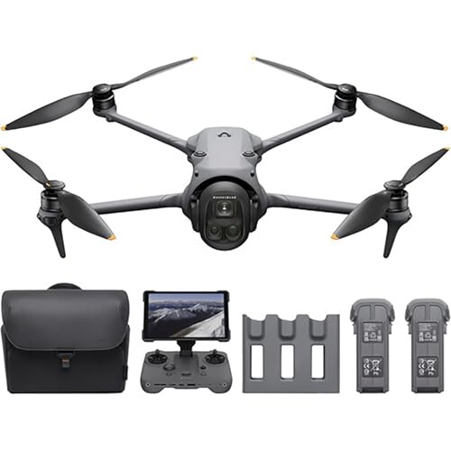
When it comes to professional-grade aerial surveying and creating highly detailed 3D models, the DJI Mavic 4 Pro (likely a placeholder for Mavic 3 Pro, given the features) is a true powerhouse. This Creator Combo is designed for serious users, featuring a remarkable 100MP Hasselblad camera with a large 4/3 CMOS sensor. This isn’t just a camera; it’s a precision instrument built to capture the intricate detail needed for top-tier photogrammetry. Add to that its dual telephoto lenses and an incredible 51-minute flight time, and you’ve got a drone ready for extensive and accurate mapping missions.
-
Key Features:
- 100MP Hasselblad Camera: 4/3 CMOS sensor, 6K/60fps HDR video, ultra-detailed 100MP photos
- Dual Telephoto Cameras: 1/1.3″ 48MP medium tele and 1/1.5″ 50MP tele lenses
- Infinity Gimbal 360° Rotation
- 0.1-Lux Nightscape Vision & Omnidirectional Obstacle Sensing
- 51-Minute Flight Time
- DJI O4+ Transmission: Ultra-reliable 10-bit HDR live video feed up to 30 km
- ActiveTrack 360° Tracking
- 4K/120fps Slow Motion Recording
- Up to 512GB Onboard Storage with UFS memory
- QuickTransfer with Wi-Fi 6
-
Pros:
- Exceptional 100MP camera and large sensor for unparalleled image detail, crucial for photogrammetry
- Long flight time allows for extensive mapping coverage per mission
- Advanced obstacle sensing ensures safer automated flight paths
- Dual telephoto lenses offer versatile perspectives, though less critical for standard photogrammetry
- High onboard storage and fast transfer speeds for efficient workflow
- Robust transmission system for reliable control over vast areas
-
Cons:
- Higher price point reflects its professional capabilities
- Larger and heavier than Mini series, requiring FAA registration
- Some features (e.g., ActiveTrack, 4K/120fps) are more focused on cinematic uses than pure mapping
- DJI Fly app removed from Google Play, requiring direct download from DJI website
-
User Impressions: Professionals consistently rate this drone highly for its incredible camera system and reliability. Users are often blown away by the sharpness and detail of the images, noting it significantly reduces post-processing effort for 3D models. The extended flight time is a game-changer for larger projects, allowing them to cover more ground efficiently.
3. DJI Mavic 4 Pro Fly More Combo with DJI RC…

The DJI Mavic 4 Pro Fly More Combo builds on the already impressive capabilities of the standard Mavic 4 Pro, adding essential accessories that make it even more suitable for serious photogrammetry and aerial surveying. The core strength remains its 100MP Hasselblad camera, delivering stunning 6K/60fps HDR video and incredibly detailed stills, which are the backbone of high-accuracy 3D models. What sets this combo apart for extensive work is the inclusion of three batteries and a charging hub, virtually eliminating downtime during critical mapping missions.
-
Key Features:
- 100MP Main Camera: Hasselblad with 6K/60fps HDR video
- Versatile Tele Images with Dual Tele Cameras
- Dynamic Angles Unleashed with 360° Infinity Gimbal
- Safe Night Flights with 0.1-Lux Nightscape Omnidirectional Obstacle Sensing
- Extended Flight Time (51 minutes per battery, 3 included)
- Long-Range Video Transmission (30km/18.6mi O4+ with 10-bit HDR)
- Pro Display On-the-Go with 7″ rotatable, high-bright RC Pro 2
- Includes DJI Mavic 4 Pro, DJI RC 2, three batteries, charging hub, and more
-
Pros:
- Ideal for extended photogrammetry missions with three batteries
- Superior image quality from the 100MP Hasselblad camera for detailed 3D models
- Advanced obstacle avoidance enhances safety for complex mapping routes
- High-bright RC Pro 2 controller improves visibility and control in various conditions
- Reliable long-range transmission for surveying large areas
- Excellent wind resistance for stable data capture
-
Cons:
- Significant investment, targeting professional users
- Heavier and less portable than the Mini series
- DJI Fly app removed from Google Play, requiring direct download from DJI website
- The dual tele cameras, while great for cinematography, are less critical for traditional photogrammetry where a consistent focal length is often preferred.
-
User Impressions: Professionals and mapping enthusiasts who rely on this combo frequently highlight the peace of mind that comes with having multiple batteries, allowing them to complete large projects without interruption. The high-resolution camera and reliable flight performance are consistently praised for delivering accurate and usable data for diverse photogrammetry applications.
4. DJI Mini 3 (DJI RC), Lightweight 3x Mechanical Gimbal…

The DJI Mini 3 (with DJI RC) is another strong contender for the title of best DJI drone for photogrammetry for hobbyists and those needing portability. Like its Mini brethren, it slides in under the 249g weight limit, sidestepping FAA registration for recreational use in many places. What truly makes the Mini 3 shine for capturing 3D data is its 4K HDR video and True Vertical Shooting capability. While the latter is great for social media, the high-quality 4K imagery combined with a stable 3-axis gimbal provides a solid foundation for smaller, precise photogrammetry projects.
-
Key Features:
- No Registration Needed (Under 249g for recreational purposes)
- 4K UHD Stunning Imagery & 4K HDR Video with Dual Native ISO Fusion
- Striking Vertical Videos with True Vertical Shooting
- Extended Battery Life (up to 51 mins with Intelligent Flight Battery Plus, sold separately; 114 mins total with Fly More combo)
- 38kph (Level 5) Wind Resistant and 3-Axis Gimbal for Stable flight
- 10km Max HD Video Transmission
- Creative Features for Advanced Shots (QuickShots, Panorama)
- Beginner-Friendly and Safe (GPS Return to Home, Precise Hovering, Auto Takeoff/Landing)
- QuickTransfer via Wi-Fi
- Includes DJI RC with pre-installed DJI Fly App and built-in 5.5-inch HD display
-
Pros:
- Extremely lightweight and portable, great for impromptu mapping
- Excellent 4K HDR image quality with a stable gimbal for clear photogrammetry data
- Strong wind resistance for its size ensures consistent imagery
- Integrated DJI RC simplifies setup and provides a bright viewing screen
- Good battery life options for extended small-scale projects
- QuickTransfer allows for fast data offloading
- No FAA registration required for recreational flights (in many regions)
-
Cons:
- Smaller sensor compared to professional mapping drones affects detail capture in complex scenarios
- Lacks advanced autonomous flight modes crucial for large, systematic photogrammetry missions
- “Intelligent Flight Battery Plus” makes it exceed 249g, requiring registration
- Not ideal for large-scale, high-precision industrial mapping
-
User Impressions: Users frequently commend the DJI Mini 3 for its user-friendliness and the high-quality visuals it captures for its size. The integrated DJI RC is a big hit, simplifying the flying experience. Many find it surprisingly capable for capturing data for smaller 3D models and personal mapping projects, often exceeding expectations for a drone in its class.
5. DJI Avata 2 Fly More Combo (3 Batteries), FPV Drones…

The DJI Avata 2 Fly More Combo is a beast of a drone, but it’s important to understand its specific niche. While it captures stunning super-wide 4K video, its primary design is for immersive FPV (First Person View) flying and dynamic, acrobatic aerial cinematography, not traditional, systematic photogrammetry. The 155° FOV (Field of View) and dynamic flight style, while thrilling, are generally not conducive to the consistent, nadir (downward-facing) image capture required for accurate 3D mapping. However, for capturing specific angles or close-up detail in challenging environments where traditional drones might struggle, its protected design and agility could offer unique perspectives.
-
Key Features:
- Unlock Adrenaline-Pumping Immersive Flying with goggles
- Intuitive Motion Control
- Compatible with various DJI Goggles and Motion Controllers
- Easy ACRO for performing flips, rolls, 180° drifts
- Tight Shots in Super-Wide 4K (155° FOV, 1/1.3-inch sensor, 4K/60fps, 4K/100fps Slow-Motion)
- Built-in Propeller Guard for Safety
- Hassle-Free POV Content, Filmmaking at launch with LightCut app
- Includes drone, 3 Intelligent Batteries, DJI RC Motion 3, DJI Goggles 3
- FAA Remote ID Compliant
- DJI Fly app activation required (download from DJI website)
-
Pros:
- Exceptionally robust with built-in propeller guards, allowing flight in confined spaces
- Captures super-wide 4K footage that could be useful for specific niche photogrammetry cases (e.g., inspecting intricate structures)
- Three batteries in the combo provide ample flight time for dynamic sessions
- Intuitive motion control offers a unique flying experience
- High-quality image sensor for excellent video clarity
-
Cons:
- Not designed for systematic, grid-based photogrammetry missions due to FPV nature and wide-angle lens distortion
- Manual control focus makes consistent image overlap challenging for mapping
- Image distortion from the 155° FOV requires significant correction for 3D modeling
- FAA Remote ID compliance means mandatory registration
- DJI Fly app removed from Google Play, requiring direct download from DJI website
-
User Impressions: Users are absolutely thrilled with the immersive flying experience and the sheer fun factor of the Avata 2. They love the agility and the ability to capture dynamic, close-up shots that other drones simply can’t. While not a typical mapping drone, some creative users might find specific applications for its unique capabilities in niche 3D modeling scenarios.
6. DJI Mini 4K Fly More Combo, Drone with 4K UHD…

The DJI Mini 4K Fly More Combo is an outstanding value package for anyone seriously considering casual photogrammetry or just wanting ample flight time. Like its single-battery counterpart, it boasts a sub-249g weight (for recreational use without registration) and a capable 4K UHD camera stabilized by a 3-axis gimbal. However, the “Fly More” part is crucial for mapping: with three batteries and a two-way charging hub included, you get significantly extended flight sessions, meaning more data captured per outing and less downtime. This extended endurance makes it a far more practical option for any kind of aerial surveying, even at an entry level.
-
Key Features:
- No Registration Needed (Under 249g for recreational use)
- 4K Ultra HD & 3-Axis Gimbal for Cinematic Quality Shooting
- 38kph (Level 5) Wind Resistant
- 10km Max HD Video Transmission
- Uninterrupted Creation with Extended Battery Life (3 batteries, 93-min total flight)
- Beginner-Friendly and Safe (GPS Return to Home, stable hovering)
- Intelligent QuickShots
- Includes DJI Mini 4K, 3 batteries, two-way charging hub, shoulder bag, and more
-
Pros:
- Excellent value with three batteries and charging hub for extended missions
- Lightweight and portable, ideal for frequent deployment for mapping
- No FAA registration required for recreational flights (in many regions)
- Stable 4K camera with 3-axis gimbal delivers good quality imagery for small models
- Robust wind resistance for consistent data capture
- User-friendly for beginners, making it easy to learn drone operation for mapping
-
Cons:
- Smaller sensor limits detail compared to professional mapping drones
- Lacks advanced autonomous flight planning tools
- DJI Fly app removed from Google Play, requiring direct download from DJI website
- Not suited for large-scale, high-accuracy industrial photogrammetry
- The bundled remote (RC-N1C) requires a smartphone, which can be less convenient than a dedicated controller with a screen.
-
User Impressions: Reviewers consistently highlight the incredible value of the Fly More Combo, emphasizing how the extra batteries transform the flying experience. Many find it perfectly suitable for capturing family memories, travel footage, and even performing small-scale mapping tasks for personal projects or hobbies, all while enjoying the peace of mind of extended flight time.
7. DJI Mini 4K, Drone with 4K UHD Camera for Adults,…

The standard DJI Mini 4K is the most affordable entry point into DJI’s lineup, offering the essential features for capturing aerial photography and basic photogrammetry. Its core strength lies in its simplicity and accessibility: a drone under 249g with a 4K UHD camera and a 3-axis gimbal, all while being incredibly easy to fly. While it comes with only one battery, making it less ideal for lengthy mapping missions, it’s a fantastic starting point for beginners to learn drone operation and the fundamentals of data capture for 3D modeling. It’s a great choice if you’re looking for the best DJI drone for photogrammetry on a tight budget.
-
Key Features:
- No Registration Needed (Under 249g for recreational use)
- 4K Ultra HD & 3-Axis Gimbal for Cinematic Quality Shooting
- 38kph (Level 5) Wind Resistant
- Uninterrupted Creation with Extended Battery Life (1 battery included)
- Beginner-Friendly and Safe (GPS Return to Home, stable hovering)
- Intelligent QuickShots
- Includes DJI Mini 4K, 1 battery, an RC-N1C remote controller, and accessories
-
Pros:
- Most affordable DJI Mini 4K option
- Ultra-portable and lightweight, easy to carry anywhere
- 4K camera with 3-axis gimbal delivers stable and clear images
- Excellent wind resistance for its small size
- Beginner-friendly with intuitive controls and safety features
- No FAA registration required for recreational flights (in many regions)
-
Cons:
- Single battery limits flight time, requiring frequent recharging for photogrammetry
- Lacks a dedicated controller screen, relying on your smartphone
- Minimal accessories compared to combo packs
- DJI Fly app removed from Google Play, requiring direct download from DJI website
- Not suitable for extensive or highly precise photogrammetry work
-
User Impressions: Customers love the Mini 4K for its incredible value and ease of use, often recommending it as a first drone. They highlight the impressive 4K video quality for such a compact device and appreciate how quickly they can get it airborne and start capturing great shots. It’s often seen as a perfect gateway drone into the world of aerial imaging and even simple 3D model creation.
FAQ Section: Your Photogrammetry Drone Questions Answered
Q1: What is photogrammetry and why use a drone for it?
A: Photogrammetry is the science of making measurements from photographs, especially for recovering the exact positions of surface points and distances between them. Using a drone for photogrammetry allows you to capture aerial images from various angles over an area efficiently and safely, which are then processed by specialized software to create 2D maps, 3D models, or even point clouds of terrains, buildings, or objects.
Q2: What are the most important features in a DJI drone for photogrammetry?
A: For effective photogrammetry, look for:
* High-Resolution Camera: Essential for capturing detailed data. A larger sensor (like a 1-inch or 4/3 CMOS) is better.
* Stable Gimbal: A 3-axis mechanical gimbal ensures blur-free, stable images, which are critical for accurate 3D reconstruction.
* Long Flight Time: More battery life means covering larger areas or more detailed scans per flight.
* Precise GPS/Positioning: Crucial for accurate georeferencing of your images. While RTK/PPK drones offer the highest precision, standard GPS is often sufficient for many applications.
* Reliable Obstacle Avoidance: Enhances safety, especially during automated mapping missions.
* Mission Planning Software: The ability to plan autonomous flight paths (e.g., grid patterns) is a significant advantage for systematic data collection (often found in higher-end models or third-party apps).
Q3: Can DJI Mini series drones be used for photogrammetry?
A: Yes, DJI Mini series drones (like the Mini 3 or Mini 4K) can definitely be used for basic photogrammetry, especially for smaller objects or areas. Their 4K cameras and stable gimbals capture decent images. However, they lack advanced features like precise waypoint navigation for complex mapping and their smaller sensors may not capture the same level of detail as professional drones like the Mavic Pro series. They are a great, affordable starting point for learning.
Q4: Do I need special software for photogrammetry with DJI drones?
A: Yes, after collecting images with your DJI drone, you’ll need specialized photogrammetry software (e.g., Pix4D, Agisoft Metashape, RealityCapture, DroneDeploy) to process those images into 3D models, orthomosaics, or point clouds. These programs align the images, create dense point clouds, and generate the final 3D outputs.
Q5: What’s the difference between consumer and professional DJI drones for mapping?
A: Professional DJI drones (like the Mavic 3 Pro, or even the Enterprise series) typically feature larger sensors, higher resolution cameras, advanced obstacle sensing, and often come with RTK/PPK modules for centimeter-level accuracy in positioning. They also integrate better with professional mission planning software. Consumer drones, while capable, usually have smaller sensors, less precise GPS (without RTK/PPK), and fewer dedicated mapping features, making them more suited for less critical or smaller-scale projects.
Q6: Why is battery life particularly important for photogrammetry?
A: For photogrammetry, you often need to cover a specific area with significant image overlap, which can take time. Longer battery life means you can complete larger mapping missions with fewer battery swaps, saving time and reducing the risk of missing data due to landing and relaunching. It also ensures more consistent lighting conditions across your dataset.
Q7: Is the DJI Avata 2 a good choice for photogrammetry?
A: The DJI Avata 2 is an excellent FPV (First Person View) drone designed for immersive flight and dynamic video, but it’s generally not ideal for traditional photogrammetry. Its super-wide 155° FOV lens introduces significant distortion that’s challenging for precise 3D reconstruction, and its FPV flying style makes systematic, consistent image capture difficult. While it can take high-quality video, its use for accurate 3D mapping is very niche and would require significant post-processing to correct for lens distortion.


