Drones have revolutionized industries worldwide, and surveying is no exception. Gone are the days of tedious, time-consuming manual measurements; now, a drone can capture vast amounts of geospatial data with incredible speed and precision. When it comes to reliable and high-quality drone technology, DJI stands out as a clear leader. Their drones are known for their advanced cameras, stable flight, and user-friendly interfaces, making them a popular choice for everything from aerial mapping to construction site monitoring.
But with so many great options, how do you pick the best DJI drone for surveying that fits your specific needs? We’re here to help! We’ve handpicked five top DJI drones, delving into their features, pros, and cons to guide you toward making an informed decision for your next photogrammetry or site inspection project. Whether you’re a seasoned professional or just starting to explore drone surveying, there’s a DJI drone here for you.
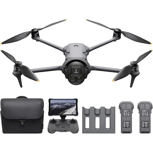
1. DJI Mini 4K Camera Drone Combo

If you’re looking for an entry point into drone-based visual inspections or need an ultra-portable solution for quick site reconnaissance, the DJI Mini 4K Camera Drone Combo is a fantastic choice. Its standout feature is its featherlight design, weighing in at under 249g, which means in many regions, you won’t need to register it with the FAA for recreational use. This makes it incredibly easy to deploy for informal visual site assessments or to capture preliminary data without the usual regulatory hurdles. Don’t let its small size fool you; the 4K UHD camera with a 3-axis gimbal ensures surprisingly stable and clear footage, perfect for capturing detailed visuals of smaller areas or specific points of interest.
Key Features:
– No Registration Needed – Under 249 g
– 4K Ultra HD & 3-Axis Gimbal for Cinematic Quality Shooting
– 38kph (Level 5) Wind Resistant & Brushless Motors
– 10km Max HD Video Transmission
– Extended Battery Life (up to 93-min with 3-battery set)
– Beginner-Friendly and Safe with GPS Return to Home (RTH)
– Intelligent QuickShots (Helix, Dronie, Rocket, Circle, Boomerang)
– Includes DJI Mini 4K, 2 batteries, DJI RC-N1C remote controller, shoulder bag, and more.
Pros:
– Ultra-lightweight and portable, ideal for quick deployments.
– No FAA registration often required, simplifying operations.
– 4K camera with 3-axis gimbal provides stable and clear visual data.
– Excellent wind resistance for its size ensures stable flight.
– Good battery life options, especially with the combo pack.
– Very user-friendly, great for beginners in visual surveying.
Cons:
– Lacks advanced mapping features like waypoint missions (without third-party apps).
– Not designed for high-precision photogrammetry or detailed 3D modeling.
– Limited sensor payload options for specialized data collection.
– DJI Fly app requires direct download from DJI’s website.
User Impressions: Customers love the Mini 4K for its portability and impressive image quality for such a small drone. Many highlight its ease of use, making it perfect for those new to drones or needing a discreet, go-anywhere camera for quick visual checks. The extended battery options are a major plus for longer missions.
2. DJI Mavic 4 Pro Fly More Combo with DJI RC

Stepping up significantly in capability, the DJI Mavic 4 Pro Fly More Combo with DJI RC is a game-changer for professional drone surveying and aerial photography. This drone is engineered for precision, featuring a groundbreaking 100MP Hasselblad camera capable of 6K/60fps HDR video, which is absolutely critical for generating high-resolution digital elevation models and detailed 3D reconstructions. The dual tele cameras add incredible versatility, allowing you to inspect distant infrastructure or challenging terrain features with crisp detail, making it a standout contender for the best DJI drone for surveying where detail and coverage are paramount. Its impressive 51-minute flight time and robust 30km video transmission mean you can cover larger areas efficiently, reducing downtime.
Key Features:
– 100MP Hasselblad Camera with 6K/60fps HDR video
– Versatile Dual Tele Cameras for crisp zooms
– 360° Infinity Gimbal for dynamic angles
– 0.1-Lux Nightscape Omnidirectional Obstacle Sensing for safe night flights
– Extended 51 minutes of flight time
– Long-Range 30km/18.6mi O4+ 10-bit HDR video transmission
– 7″ rotatable, high-bright remote controller RC Pro 2
– Includes DJI Mavic 4 Pro, DJI RC 2, three batteries, charging hub, and more.
Pros:
– Exceptional 100MP camera for ultra-high-resolution imagery, perfect for photogrammetry.
– Long flight time allows for extensive area coverage per flight.
– Advanced obstacle avoidance ensures safer flights in complex environments.
– Dual telephoto lenses enhance inspection capabilities for specific details.
– High-quality O4+ transmission provides a reliable and clear live feed.
– RC Pro 2 controller offers superior control and a bright display for outdoor use.
Cons:
– Higher price point compared to entry-level drones.
– Larger and heavier than Mini series, requiring FAA registration for commercial use.
– DJI Fly app requires direct download from DJI’s website.
User Impressions: Users consistently praise the Mavic 4 Pro for its stunning image quality and extended flight capabilities. Professionals frequently highlight its reliability and the clarity of its Hasselblad camera, noting its transformative impact on their data acquisition workflows. The long battery life and superior remote controller are also frequently cited as major advantages.
3. DJI Avata 2 Fly More Combo (3 Batteries)

The DJI Avata 2 Fly More Combo offers a radically different perspective on aerial data collection, bringing the immersive thrill of FPV (First-Person View) flight to specialized site visualization and inspection tasks. While not a traditional photogrammetry drone, its unique capabilities make it invaluable for specific surveying applications. Imagine navigating through complex structures, inside confined spaces, or under bridges with unparalleled agility thanks to its intuitive motion control. The 155° FOV ultra-sharp 4K camera (1/1.3-inch sensor) is superb for capturing comprehensive visual data in dynamic environments, and its built-in propeller guard provides an extra layer of safety, letting you get those tight, detailed shots in areas where other drones might struggle.
Key Features:
– Adrenaline-Pumping Immersive Flying (with goggles)
– Intuitive Motion Control for easy flight
– Compatible with multiple DJI Goggles and RC units
– Easy ACRO for professional-level maneuvers
– Tight Shots in Super-Wide 4K (4K/60fps, 4K/100fps Slow-Motion)
– Built-in Propeller Guard for enhanced safety
– Hassle-Free POV Content, Filmmaking at launch
– Includes drone, 3 Intelligent Batteries, DJI RC Motion 3, DJI Goggles 3, and more.
– FAA Remote ID Compliant
Pros:
– Exceptional agility and ability to navigate tight, complex spaces.
– Immersive FPV experience for detailed, close-up visual inspections.
– Built-in propeller guards enhance safety in challenging environments.
– Super-wide 4K FOV is excellent for comprehensive visual capture.
– Easy ACRO modes allow for impressive dynamic footage.
– Long flight time with the 3-battery combo.
Cons:
– Not ideal for large-scale, systematic mapping or photogrammetry grids.
– Requires FPV goggles for the full immersive experience, which might not suit all users.
– Learning curve for FPV flying, though motion control simplifies it.
– Primarily focused on visual data rather than survey-grade precise measurements.
User Impressions: FPV enthusiasts and professionals needing dynamic close-up visual data absolutely love the Avata 2. Users highlight its robust design, incredible maneuverability, and the thrilling yet controlled flight experience. The enhanced safety from the propeller guards is frequently praised for allowing flights in areas previously inaccessible to standard drones.
4. DJI Mavic 4 Pro Drone 512GB Creator Combo (DJI RC
For the surveying professional who demands the absolute best in image quality, storage, and workflow efficiency, the DJI Mavic 4 Pro Drone 512GB Creator Combo is the ultimate tool. This package takes the already incredible Mavic 4 Pro and supercharges it with massive onboard storage, making it perfectly suited for extended data acquisition missions and high-spec filmmaking where every frame counts. The 100MP Hasselblad camera with its 4/3 CMOS sensor remains the star, delivering stunning 6K/60fps HDR video and ultra-detailed 100MP photos vital for precise land measurement and topographic surveys. With 51 minutes of flight time and an ultra-reliable O4+ transmission system, this drone ensures your aerial mapping projects are completed with unparalleled quality and efficiency.
Key Features:
– 100MP Hasselblad Camera: 4/3 CMOS sensor, 6K/60fps HDR video, 100MP photos
– Dual Telephoto Cameras: 1/1.3″ 48MP medium tele and 1/1.5″ 50MP tele lenses
– Infinity Gimbal 360° Rotation for cinematic freedom
– 0.1-Lux Nightscape Vision with omnidirectional obstacle sensing and LiDAR
– 51-Minute Flight Time with high-capacity 95Wh battery
– DJI O4+ Transmission: Ultra-reliable 10-bit HDR live video feed up to 30 km
– ActiveTrack 360° Tracking for cinematic focus
– 4K/120fps Slow Motion Recording
– Up to 512GB Onboard Storage: ALL-I 4:2:2 encoding, ultra-fast UFS memory
– QuickTransfer with Wi-Fi 6 for fast file transfer (80MB/s)
Pros:
– Massive 512GB onboard storage is ideal for large surveying projects and high-resolution data.
– 100MP Hasselblad camera delivers industry-leading image quality for photogrammetry.
– Long flight time and advanced obstacle avoidance boost operational efficiency and safety.
– Dual telephoto lenses offer versatile inspection capabilities for infrastructure inspection.
– Wi-Fi 6 QuickTransfer dramatically speeds up workflow by offloading data quickly.
– LiDAR integration enhances obstacle avoidance and potentially future precision mapping applications.
Cons:
– Premium price tag makes it a significant investment.
– Requires proper training and understanding for full utilization in professional surveying.
– Larger and heavier, necessitating FAA registration for commercial operations.
User Impressions: This creator combo is revered by professionals for its unparalleled image quality, robust build, and extended capabilities. The huge internal storage and fast transfer speeds are particularly appreciated by those dealing with large geospatial datasets, streamlining their post-processing workflow significantly. It’s consistently rated as the ultimate tool for demanding aerial imaging tasks.
5. DJI Mini 4K Fly More Combo, Drone with 4K UHD

Similar to the Mini 4K Camera Drone Combo, the DJI Mini 4K Fly More Combo enhances the experience by including more batteries and essential accessories, making it an even better value for those needing extended operation without the complexities of larger drones. This combo is an excellent choice if you’re undertaking multiple small-scale visual inspections or need to capture extensive preliminary visual data without constant battery swaps. The core features, like the sub-249g weight and the 4K UHD camera with a 3-axis gimbal, remain, ensuring you get stable, high-quality visuals for initial site assessments or progress monitoring on smaller projects. It’s truly a top pick for anyone seeking the best DJI drone for surveying at a budget-friendly price point for visual data.
Key Features:
– No Registration Needed – Under 249 g
– 4K Ultra HD & 3-Axis Gimbal for Cinematic Quality Shooting
– 38kph (Level 5) Wind Resistant
– 10km Max HD Video Transmission
– Uninterrupted Creation with Extended Battery Life (93-min with 3 batteries)
– Beginner-Friendly and Safe (one-tap takeoff/landing, GPS RTH)
– Boost Your Inspiration with Intelligent QuickShots
– Includes DJI Mini 4K, 3 batteries, a two-way charging hub, shoulder bag, and more.
Pros:
– Extended flight time with three batteries in the combo, reducing downtime.
– Extremely portable and lightweight, ideal for rapid deployment and easy transport.
– 4K camera provides crisp visual data for inspections and preliminary surveys.
– No FAA registration often required, simplifying use for visual checks.
– Very easy to fly, even for beginners in drone technology.
– Cost-effective solution for visual asset management or small-scale visual data collection.
Cons:
– Not built for high-accuracy photogrammetry or large-scale mapping.
– Limited payload options for specialized sensors.
– DJI Fly app requires direct download from DJI’s website.
User Impressions: Reviewers rave about the Mini 4K Fly More Combo’s incredible value, especially the added flight time from the extra batteries. It’s widely regarded as the ultimate travel companion and an excellent tool for capturing stunning footage or performing quick visual surveys without being bogged down by complex regulations or heavy gear.
Frequently Asked Questions (FAQ)
Q1: What features are essential for a DJI drone for professional surveying?
A1: For professional surveying, look for high-resolution cameras (e.g., 100MP or 4K/6K video) with large sensors, stable gimbals, long flight times (over 30 minutes), advanced obstacle avoidance, reliable long-range transmission, and compatibility with third-party photogrammetry software. GPS for precise positioning is also crucial.
Q2: Can I use a DJI Mini drone for professional surveying?
A2: While DJI Mini drones excel at capturing high-quality visual data, they are generally best suited for visual inspections, preliminary site assessments, or progress monitoring on smaller sites. For high-accuracy photogrammetry and creating precise 3D models or digital elevation models, drones like the Mavic 4 Pro with their larger sensors and advanced features are typically recommended.
Q3: Do I need special software for drone surveying?
A3: Yes, for converting the raw aerial images captured by your drone into actionable geospatial data, you’ll need specialized photogrammetry software. Popular options include DJI Terra, Pix4Dmapper, Agisoft Metashape, and RealityCapture. These tools stitch images together, create orthomosaics, 3D models, and other survey deliverables.
Q4: What’s the difference between photogrammetry and LiDAR drones for surveying?
A4: Photogrammetry drones (like most DJI models) use optical cameras to capture overlapping images, which are then processed by software to create 3D models and maps. LiDAR (Light Detection and Ranging) drones use laser pulses to directly measure distances to the ground, creating highly accurate point clouds. LiDAR is generally more accurate in areas with dense vegetation or poor lighting but comes at a much higher cost. Most DJI drones are excellent for photogrammetry, but they do not feature integrated LiDAR.
Q5: How do I ensure accuracy in drone surveys?
A5: To ensure high accuracy, use ground control points (GCPs), maintain consistent flight altitude and image overlap (typically 70-80% front and side overlap), calibrate your drone’s camera, and use a drone with RTK/PPK capabilities (if available and needed for sub-centimeter accuracy, though not standard on all consumer DJI models listed).
Q6: What are the legal requirements for flying a DJI drone for surveying?
A6: Legal requirements vary by region. In the USA, if you’re flying for commercial purposes, you generally need to obtain a Part 107 Remote Pilot Certificate from the FAA. All drones over 0.55 lbs (250g) usually require FAA registration, and most newer drones (including the Avata 2 and Mavic 4 Pro) need to be Remote ID compliant. Always check your local aviation authority’s regulations before flying.
Q7: What is the ideal flight time for a surveying drone?
A7: A longer flight time is always better for surveying, as it allows you to cover larger areas with fewer battery swaps, improving efficiency. Ideally, look for drones with flight times of 30 minutes or more. The DJI Mavic 4 Pro, for instance, offers an impressive 51 minutes, significantly boosting workflow efficiency for large-scale projects.
Conclusion
Choosing the best DJI drone for surveying truly boils down to your specific project needs, desired accuracy, and budget. For quick visual inspections and affordability, the DJI Mini 4K series offers incredible value. If you’re tackling professional aerial mapping and photogrammetry projects demanding the highest resolution and longest flight times, the DJI Mavic 4 Pro series is an undisputed champion. And for those unique, dynamic inspections in challenging environments, the DJI Avata 2 provides an unmatched immersive experience.
No matter which DJI drone you choose, you’re investing in reliable drone technology that can significantly enhance your land measurement and data collection capabilities. Remember to always consider the supporting software, legal regulations, and your skill level to maximize the potential of your new aerial surveying tool. Happy flying!


