Featured image for this comprehensive guide about what is a gps drone?
Image source: radar-toulouse.fr
What is a GPS Drone? The Ultimate Guide to Modern Drone Technology
Remember when drones felt like a futuristic concept, limited to military applications or high-budget sci-fi movies? Fast forward to today, and these incredible flying machines are buzzing everywhere, from capturing breathtaking wedding footage to inspecting colossal infrastructure. But not all drones are created equal. Among the vast array of aerial vehicles, one type stands out for its stability, precision, and advanced capabilities: the GPS drone.
Imagine a drone that knows exactly where it is, can return to its starting point with uncanny accuracy, and even follow a pre-programmed flight path – all thanks to a tiny, sophisticated chip communicating with satellites orbiting Earth. This isn’t science fiction; it’s the everyday reality of modern drones with GPS. Whether you’re a seasoned pilot, a budding aerial photographer, or a professional looking to leverage cutting-edge technology, understanding what a GPS drone is and how it works is fundamental to unlocking its full potential. Let’s dive deep into the world of these intelligent flying robots and discover what makes them so revolutionary.
Quick Answers to Common Questions
What exactly is a GPS drone?
A GPS drone is simply a drone equipped with a Global Positioning System receiver, allowing it to know its precise location in the sky at all times. This technology is key for enabling more advanced and stable flight features.
Why is GPS important for a drone?
GPS is crucial because it gives your drone incredible stability, especially in windy conditions, and unlocks smart flight modes. It helps the drone hold its position automatically, making flying much less stressful.
What practical things can a GPS drone do that others can’t?
GPS drones can perform amazing feats like “Return-to-Home,” where they fly back to their launch point with a push of a button, or follow you automatically. They also allow for waypoints and stable hovering, which is super handy for photography.
Are GPS drones harder to fly for beginners?
Actually, it’s often the opposite! GPS makes flying much easier for beginners by providing automatic stability and preventing the drone from drifting away. You’ll find learning to fly a GPS drone is much more forgiving.
What’s the biggest benefit of having a GPS drone?
The biggest benefit of a GPS drone is enhanced reliability and safety, giving you peace of mind during flight. Knowing your drone can accurately hold its position and return home safely makes the experience much more enjoyable.
📋 Table of Contents
- Understanding the Core Technology: What is a GPS Drone?
- The Unsung Heroes: Key GPS Features and Functions
- Why Choose a GPS Drone? Unpacking the Benefits
- Navigating the Skies: Best Practices for Flying Your GPS Drone
- Beyond Hobby: Professional and Commercial Applications of GPS Drones
- Choosing Your Perfect GPS Drone: Factors to Consider
- Conclusion: The Future is Flying on GPS
Understanding the Core Technology: What is a GPS Drone?
At its heart, a GPS drone is an unmanned aerial vehicle (UAV) equipped with a Global Positioning System (GPS) receiver. This receiver communicates with orbiting GPS satellites, allowing the drone to triangulate its exact position on Earth. It’s like your smartphone’s navigation system, but for flight.
Learn more about what is a gps drone? – what is a gps drone?
Image source: osydistribuidores.com
This technology provides real-time, accurate positional data (latitude, longitude, altitude) to the drone’s flight controller. Without GPS, drones rely on internal sensors and manual input, struggling against wind. With GPS, the drone gains spatial awareness, enabling advanced features for intuitive, precise operation.
| Feature | GPS Drone (Enabled by GPS) | Standard Drone (Without GPS) |
|---|---|---|
| **Positioning & Hover** | Maintains precise position and altitude automatically (e.g., horizontal accuracy ±0.5m). | Prone to drifting, requires constant manual correction to hold position. |
| **Advanced Flight Modes** | Supports Waypoint Navigation, Follow Me, Orbit, and TapFly. | Limited to basic manual flight controls. |
| **Return-to-Home (RTH)** | Automatically returns to its take-off point on low battery, signal loss, or pilot command. | No automated RTH; pilot must manually fly it back. |
| **Stability & Wind Resistance** | Enhanced stability in light to moderate winds (e.g., up to 20-30 km/h) due to position lock. | Highly susceptible to wind drift, making stable flight difficult. |
| **Ease of Piloting** | Easier to fly, especially for beginners, due to automated stability and intelligent controls. | More challenging, requires significant practice to maintain stable flight. |
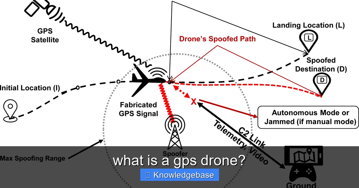
How GPS Works in Drones: A Simplified Explanation
How GPS works in drones involves these key steps:
- Signal Reception: The drone’s GPS receiver picks up signals from multiple GPS satellites (at least four for 3D positioning).
- Data Triangulation: By measuring signal travel time from satellites, the drone calculates its distance from each one.
- Position Calculation: Using these distances, the flight controller pinpoints the drone’s precise 3D coordinates (latitude, longitude, altitude).
- Continuous Updates: The drone constantly updates its position, multiple times per second, crucial for stable flight.
- Integration with Flight Control: GPS data feeds into the flight system, making real-time adjustments to motors for stable flight, precise position hold, or complex maneuvers.
GPS drone navigation systems vary in accuracy. Modern advanced drone technology often integrates other GNSS (GLONASS, Galileo, BeiDou) for enhanced reliability, especially in challenging environments.
The Unsung Heroes: Key GPS Features and Functions
GPS integration transforms drones into intelligent aerial platforms. These GPS drone features are fundamental to safe, efficient, and precise operation, benefitting both hobbyists and professionals.
Learn more about what is a gps drone? – what is a gps drone?
Image source: m.media-amazon.com
1. Position Hold (Hovering Stability)
One of the most valuable features, position hold allows the GPS drone to automatically maintain its exact location and altitude, even in wind. Essential for stable aerial photography and simplifies flying for beginners.
2. Return-to-Home (RTH)
A critical safety feature, RTH automatically brings the GPS drone back to its takeoff point and lands it safely if signal is lost, battery is low, or activated by the pilot. Reduces risk of loss.
3. Waypoint Navigation
Pilots pre-program a precise flight path using GPS coordinates. The drone autonomously follows this path, performing actions at waypoints. Invaluable for repeatable tasks like mapping, common in commercial GPS drones.
4. Follow Me Mode
Tracks a GPS signal (from controller/device) to autonomously follow a subject, maintaining set distance and altitude. Provides hands-free, dynamic video capture for adventurers and content creators.
5. Geo-fencing and No-Fly Zones
GPS technology enables geo-fencing (virtual boundaries) and pre-programmed ‘no-fly zones’ (e.g., near airports), preventing unauthorized flight and promoting safe drone operation.
Why Choose a GPS Drone? Unpacking the Benefits
Choosing a GPS drone offers numerous advantages, profoundly enhancing safety, reliability, and capabilities for all users.
- Enhanced Stability and Ease of Use: GPS drones are significantly easier to fly due to superior position hold. They hover predictably, simplifying control for beginners and ensuring smooth, professional footage.
- Increased Safety and Reliability: RTH and geo-fencing features offer peace of mind, automatically returning the drone or preventing restricted area entry. This vastly reduces flyaways and crashes, promoting safe drone operation.
- Precision for Professional Applications: For tasks like surveying or inspection, GPS drones follow exact flight paths and capture highly accurate data, making them essential for commercial operations. The global commercial drone market, projected to exceed $58 billion by 2026 (Statista, 2023), is driven by these precise capabilities.
- Advanced Autonomous Flight Capabilities: Waypoint navigation and Follow Me automate complex maneuvers, saving time and enabling tasks impossible with manual flight. This showcases advanced drone technology.
- Better Quality Media Capture: Stable hovering and precise flights directly yield higher quality aerial photography and videography, minimizing shaky or blurry footage for professional-grade content.
Navigating the Skies: Best Practices for Flying Your GPS Drone
While GPS drones offer automation, responsible piloting requires best practices to maximize your advanced drone technology’s potential and understand its limitations.
1. Pre-Flight Checks and Calibration
Always perform thorough pre-flight checks (battery, propellers, firmware). Crucially, conduct a compass calibration before the first flight in a new location for accurate GPS positioning.
2. Understand GPS Signal Limitations
Fly in open areas, away from tall buildings or interference. Weak GPS signals cause drift or ATTI mode. Ensure sufficient satellite acquisition (7-10 recommended) before takeoff.
3. Monitor Battery Life and RTH Settings
Continuously monitor battery. Understand RTH activation (low battery, signal loss) and set RTH altitude to clear obstacles. Land with a safe reserve.
4. Adhere to Local Regulations and No-Fly Zones
You are responsible for legal and safe flight. Know local drone laws, altitude limits, no-fly zones, and registration. Respect privacy and check for temporary flight restrictions (TFRs).
5. Practice Manual Flight Skills
Practice flying in ATTI mode (if available). This builds essential manual piloting skills, invaluable if GPS signal is lost or in challenging conditions, making you a more versatile pilot.
Beyond Hobby: Professional and Commercial Applications of GPS Drones
The stability and precision of GPS drones have made them indispensable tools across numerous industries. These commercial GPS drones transform workflows, enhancing safety and data collection. A 2022 PwC report noted the drone-powered solutions market could reach over $127 billion.
1. Surveying and Mapping
GPS drones with high-resolution cameras/sensors (LiDAR) revolutionize surveying, creating accurate 2D maps and 3D models. More efficient and safer than traditional methods for construction, urban planning, and environmental management. Drone mapping GPS is key.
2. Agriculture and Crop Monitoring
In precision agriculture, drones with GPS monitor crop health, identify issues (pests, disease), and optimize resource use. Multispectral cameras reveal plant stress, improving yields and reducing waste.
3. Infrastructure Inspection
Inspecting critical infrastructure (bridges, power lines) is safer and faster with GPS drones. They capture HD imagery and thermal data, identifying defects and minimizing human risk. A major growth area for commercial GPS drones.
4. Search and Rescue (SAR)
Thermal-equipped GPS drones are invaluable in SAR. They quickly cover large areas, locate missing persons, and assess disaster zones from a safe distance, providing critical real-time situational awareness.
5. Real Estate and Media Production
For stunning aerial photography/videography, GPS drones are indispensable. Stable flight and precise control enable cinematic footage for real estate, film, and advertising, elevating visual storytelling.
Choosing Your Perfect GPS Drone: Factors to Consider
Choosing the right GPS drone from many models can be daunting. Your ideal drone depends on intended use, skill level, and budget. Here’s how to decide:
1. Intended Use: Hobbyist, Prosumer, or Professional?
- Hobbyist/Beginner: Seek user-friendly models with RTH, position hold, basic obstacle avoidance for casual use.
- Prosumer/Advanced Hobbyist: Prioritize 4K/60fps+ cameras, longer flight times, and advanced intelligent modes like waypoint navigation.
- Professional/Commercial: Requires specialized drones with tailored features (sensors), enterprise software, and high reliability for industry tasks.
2. Camera Quality and Gimbal
For media, look for 4K+ resolution, good frame rates, adequate sensor, and a 3-axis gimbal for smooth footage. Professional models may offer interchangeable lenses.
3. Battery Life and Range
Longer battery life (20-30+ minutes) means more flight time. Consider transmission range for reliable connection, prioritizing signal stability.
4. Intelligent Flight Modes and Safety Features
Evaluate intelligent modes (Waypoint, Follow Me) and robust obstacle avoidance systems (multi-directional sensors) for enhanced safety.
5. Portability and Durability
If traveling, consider size/weight (foldable designs help). Durability against dust/water is important for outdoor use.
6. Brand Reputation and Ecosystem
Choose reputable brands known for quality, support, and a good accessory/software ecosystem. Leaders offer reliable advanced drone technology.
Comparative Overview of GPS Drone Features (Illustrative)
To help visualize the differences, here’s a simplified table comparing typical features across various GPS drone categories:
| Feature/Category | Beginner/Entry-Level GPS Drone | Advanced Hobbyist/Prosumer GPS Drone | Professional/Commercial GPS Drone |
|---|---|---|---|
| Typical Price Range | $200 – $600 | $700 – $2,000 | $2,500 – $20,000+ |
| Camera Quality | 1080p – 2.7K, fixed lens | 4K/30-60fps, larger sensor, often adjustable aperture | 4K/6K/8K, interchangeable lenses, specialized sensors (LiDAR, thermal, multispectral) |
| Flight Time | 15-20 minutes | 25-35 minutes | 30-45 minutes (often with hot-swappable batteries) |
| Obstacle Avoidance | Basic (front/downward sensors) | Multi-directional (front, back, side, downward) | Omnidirectional, highly sophisticated (with AI/RTK integration) |
| Intelligent Flight Modes | Position Hold, RTH, basic Follow Me | Waypoint Navigation, Advanced Follow Me, ActiveTrack, Hyperlapse | Precision Waypoint, RTK/PPK mapping, custom mission planning, object tracking |
| GPS Accuracy | ~1-3 meters horizontal | ~0.5-1 meter horizontal | Centimeter-level accuracy (with RTK/PPK) |
| Target User | First-time pilots, casual users | Content creators, serious hobbyists | Surveyors, inspectors, farmers, filmmakers, emergency services |
This table is a general guide; specific models will have varying features within these categories.
Conclusion: The Future is Flying on GPS
Understanding “what is a GPS drone?” reveals a fascinating blend of aerospace, satellite, and software tech. These machines have transformed aerial interaction, offering stability, precision, and autonomous capabilities. From hobbyists to industry, the GPS drone is a testament to innovation.
As technology evolves, expect greater accuracy (RTK/PPK), longer flight times, and more intelligent autonomous functions. Whether choosing your first or upgrading, a drone with GPS unlocks modern aerial technology’s full potential. It’s about flying smarter, safer, and with unprecedented control. The skies are an open canvas, explored with GPS precision.
🎥 Related Video: Best Drone Gps 🔥 1km range brushless motor 4k WiFI camera foldable drone Mavic 3 / D31 drone
📺 KD TECH PRO
Mavic 3 drone gpsdrone Brushless motor Drone Best Foldable Drone with dual camera Wifi Connectivity Drone price 9990 BUY …
Frequently Asked Questions
What exactly is a GPS drone?
A GPS drone is an unmanned aerial vehicle (UAV) equipped with a Global Positioning System receiver. This technology allows the drone to accurately determine its own location in three-dimensional space, providing enhanced stability and advanced flight capabilities.
How does a GPS drone know where it is?
A GPS drone identifies its precise location by receiving signals from multiple satellites orbiting Earth. By triangulating these signals, the drone’s onboard computer can accurately calculate its latitude, longitude, and altitude, enabling it to maintain position.
What are the main advantages of using a GPS drone?
GPS drones offer significant advantages like improved flight stability, precise hovering, and automated flight paths. They also enable crucial safety features such as “Return-to-Home” (RTH) and geofencing, making them easier and safer to operate.
What is the “Return-to-Home” feature on a GPS drone?
The “Return-to-Home” (RTH) feature allows a GPS drone to automatically fly back to its takeoff point when activated. This function is typically triggered by a low battery, loss of signal, or manual command, significantly reducing the risk of losing your drone.
Are GPS drones more difficult for beginners to fly?
On the contrary, GPS drones often make flying easier for beginners due to their enhanced stability and intelligent flight modes. The GPS system helps the drone maintain its position against wind and allows for more predictable movements, reducing the learning curve.
Can I fly a GPS drone without a GPS signal?
While a GPS drone can technically be flown without a GPS signal (e.g., indoors or under heavy cover), it will lose most of its advanced features. Without GPS, the drone will not be able to hold its position automatically, use Return-to-Home, or follow precise flight paths, relying solely on manual control and potentially vision positioning systems if available.


