Featured image for this comprehensive guide about what is dji authorization zone?
Image source: cdn.mos.cms.futurecdn.net
The sky once represented boundless freedom, especially for drone enthusiasts. Yet, as the popularity of unmanned aerial vehicles (UAVs) soared, so did the need for structure, safety, and regulation. Enter DJI Authorization Zones – a crucial, often misunderstood, component of responsible drone operation. For many, encountering a “restricted zone” alert on their DJI app can be a source of frustration or confusion. What exactly do these alerts mean? Why are they there? And how can you navigate them legally and safely?
Far from being arbitrary roadblocks, DJI Authorization Zones are an integral part of DJI’s comprehensive Geo-System, designed to prevent drones from inadvertently flying into sensitive or restricted airspace. They are a technological safeguard, protecting everything from busy airports and critical infrastructure to national security sites and public events. Understanding these zones isn’t just about avoiding an error message; it’s about ensuring flight safety, maintaining public trust in drone technology, and adhering to both manufacturer guidelines and national aviation regulations. This post will demystify DJI Authorization Zones, providing you with the knowledge and tools to fly safely and responsibly.
Quick Answers to Common Questions
What exactly is a DJI authorization zone?
A DJI authorization zone is a specific area designated by DJI where drone flight is restricted due to safety or security concerns. These zones are typically near airports, prisons, power plants, or other sensitive locations to prevent accidental or unauthorized drone flights.
Why does DJI have these authorization zones?
DJI implements these zones to enhance air safety and comply with local aviation regulations worldwide. They’re a crucial part of DJI’s geofencing system, helping to prevent drones from flying into sensitive airspace where they could pose a risk.
Can I just fly my DJI drone in a DJI authorization zone?
No, you generally cannot just fly your drone in a DJI authorization zone without taking specific steps. Your drone will typically be prevented from taking off or will be limited in flight altitude within these areas unless you’ve unlocked the zone.
How do I find out if I’m flying in a DJI authorization zone?
You can easily check if your intended flight area is a DJI authorization zone using the DJI Fly app or DJI GO 4 app, which displays these zones on its map. You can also visit DJI’s official geozone map on their website before you head out.
What do I need to do if I want to fly in a DJI authorization zone for a legitimate reason?
If you have a valid reason and proper authorization to fly in a DJI authorization zone, you’ll need to unlock the zone through DJI’s self-unlocking or custom unlocking process. This typically involves verifying your identity and providing flight details directly through DJI’s platforms.
📋 Table of Contents
- Demystifying the DJI Geo-System: More Than Just No-Fly Zones
- Diving Deeper into DJI Authorization Zones: Understanding the “Unlock” Concept
- Navigating the DJI Fly Safe Database: Your Essential Tool
- Best Practices for Flying in or Near Authorization Zones
- Common Misconceptions and Troubleshooting Tips
- The Future of Drone Airspace Management and DJI’s Role
- Conclusion: Fly Smart, Fly Safe, Fly Legal
Demystifying the DJI Geo-System: More Than Just No-Fly Zones
Before we dive deep into DJI Authorization Zones, it’s essential to grasp the broader context: the DJI Geo-System. Think of it as an intelligent, dynamic air traffic control system built directly into your DJI drone’s software. It’s designed not to restrict your fun, but to enhance safety for everyone, both in the air and on the ground.
Learn more about what is dji authorization zone? – what is dji authorization zone?
Image source: pbs.twimg.com
What is the DJI Geo-System?
The DJI Geo-System is a sophisticated, GPS-based geofencing system integrated into all modern DJI drones. It uses real-time location data to identify the drone’s position relative to predefined airspace restrictions. These restrictions are based on a vast database of global airspace information, continually updated by DJI using official sources and publicly available data from aviation authorities worldwide. When your drone approaches or attempts to enter a specific “geo zone,” the system will either warn you, prevent takeoff, or limit its flight capabilities, depending on the zone’s classification.
| Zone Type | Description | Pilot Action Required | Key Implication/Purpose |
|---|---|---|---|
| Warning Zone | Areas where flight may pose safety or security concerns (e.g., near airports, major events, residential areas). | Pilot receives an in-app warning; can proceed after acknowledging understanding of potential risks. | Promotes pilot awareness of sensitive areas; flight is generally permitted but encouraged with caution. |
| Authorization Zone | Flight in these areas is restricted and requires unlocking, typically around airfields, government facilities, or critical infrastructure. | Requires a verified DJI account; may need to apply for an “unlock” via DJI’s website or app. | Ensures pilots are authorized and aware of moderate restrictions; enhances safety around controlled airspace. |
| Restricted Zone | Highly sensitive or dangerous areas where flight is strictly prohibited without explicit, often advanced, permission. | Drone flight is prevented by default. Requires direct contact with DJI support and/or local authorities for special unlocking. | Prevents flights in critical national security or public safety areas (e.g., military bases, active wildfires). |
| Altitude Zone | Areas where flight is permitted, but the drone’s maximum altitude is limited to a specific height, regardless of other zone types. | Drone’s maximum flight height is automatically restricted; pilot must adhere to the specified altitude limit. | Manages airspace at lower levels; ensures compliance with local flight height regulations and avoids obstacles. |
The Philosophy Behind Geofencing
The core philosophy behind geofencing, particularly the DJI Geo-System, is proactive safety. Rather than solely relying on pilots to know every single airspace restriction, the system provides an automated layer of protection. This is especially vital given the rapid growth of the drone industry and the varying levels of experience among pilots. Geofencing aims to:
- Prevent Accidental Incursions: Stop drones from flying into sensitive areas like airports, prisons, or government facilities.
- Enhance Public Safety: Reduce the risk of collisions with manned aircraft or injury to people on the ground.
- Promote Regulatory Compliance: Help pilots adhere to local and international aviation laws.
- Protect Privacy and Security: Prevent unauthorized surveillance or interference in restricted areas.
In essence, it’s a digital safety net, guiding pilots towards responsible operation and mitigating potential risks associated with drone misuse or ignorance of regulations.
Types of DJI Geo Zones
The DJI Geo-System categorizes airspace into several distinct zones, each with different implications for flight. Understanding these categories is the first step to truly comprehending DJI Authorization Zones.
- Restricted Zones: These are the strictest zones (e.g., major international airports, nuclear power plants). Flight is generally prohibited, and even with special authorization, unlocking is typically not possible through the DJI app. These often require direct contact with DJI and relevant authorities.
- Authorization Zones: Our main topic! These areas require a verified DJI account and a specific unlock procedure to fly. They include smaller airports, some government facilities, and densely populated urban areas.
- Enhanced Warning Zones: These zones advise caution. While flight is permitted, you’ll receive a warning message in the DJI app, reminding you of potential risks (e.g., areas with high pedestrian traffic, temporary flight restrictions). You can choose to proceed with a simple self-confirmation.
- Warning Zones: These provide informational alerts about potential hazards (e.g., wildlife protection areas, local events). Flight is generally permitted without special action, but awareness is key.
- Altitude Zones: These zones, often found around airports, impose specific altitude limitations, even if horizontal flight is permitted.
- Recommended Flight Zones: These areas are identified as generally safe for drone operation, often designated for recreational flying.
Each type is visually represented on the DJI Fly Safe Map (available on DJI’s website and within the DJI apps) with distinct colors, making it easier for pilots to identify and understand the associated restrictions.
Diving Deeper into DJI Authorization Zones: Understanding the “Unlock” Concept
Of all the zone types, DJI Authorization Zones strike a balance between strict prohibition and outright permission, introducing the critical concept of “unlocking.” This mechanism recognizes that while an area might be sensitive, legitimate reasons for drone operations (e.g., commercial photography, inspection, public safety) can exist, provided proper procedures are followed.
Learn more about what is dji authorization zone? – what is dji authorization zone?
Image source: i.ytimg.com
What Exactly is an Authorization Zone?
A DJI Authorization Zone is an area where flight is restricted by default, but can be permitted after the pilot completes an “unlock” procedure. These zones typically encompass locations where unauthorized drone activity could pose a significant risk but where controlled, authorized operations are also common. Examples include:
- Most regional airports and helipads.
- Certain government buildings and facilities.
- Prisons and correctional facilities.
- Key infrastructure like power stations or water treatment plants.
- Major sports stadiums or event venues (often temporary).
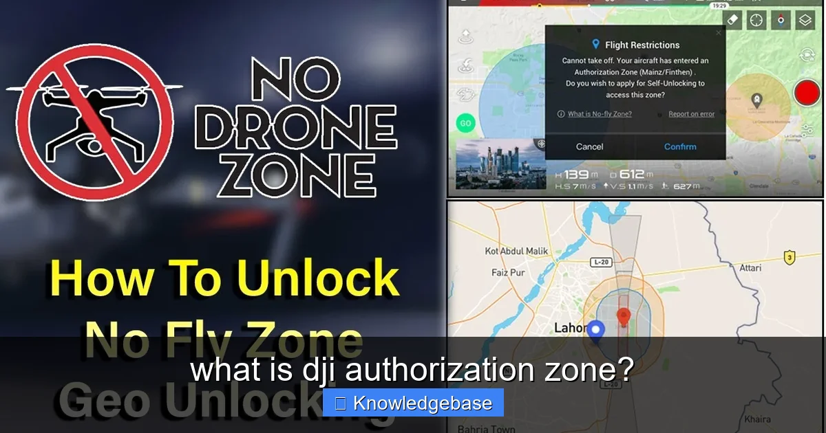
When your DJI drone’s GPS detects it’s within or attempting to enter an Authorization Zone, it will prevent takeoff or restrict flight until a valid unlock has been activated. This isn’t a permanent block; it’s an intelligent pause, prompting you to verify your legitimacy and awareness of the local regulations.
Why Do Authorization Zones Exist?
The existence of DJI Authorization Zones is rooted in mitigating specific, identifiable risks. Consider the implications of unauthorized drone flights:
- Aircraft Safety: A drone near an airport, even a small regional one, poses a collision risk to manned aircraft during critical phases of flight like takeoff and landing. The FAA, for instance, reported over 1,700 drone sightings near airports or aircraft in 2019 alone, highlighting the pervasive nature of this concern.
- Security Concerns: Sensitive government sites, military bases, or critical infrastructure could be vulnerable to surveillance or interference from unauthorized drones.
- Public Safety & Privacy: Drones flying over crowds or private property without authorization can raise serious safety and privacy issues. Prisons, for example, are frequently subjected to drone-aided contraband delivery attempts, making these zones critical for security.
By requiring an unlock, DJI ensures that pilots operating in these areas are consciously aware of the restrictions, have a legitimate reason to fly, and have often taken steps to secure necessary permits or permissions from local authorities.
The Process of Unlocking: A Step-by-Step Guide
Unlocking an Authorization Zone is a straightforward process, but it requires preparation and a clear understanding of your responsibilities. It primarily involves using the DJI Fly Safe website or the DJI GO 4 / DJI Fly app.
1. Verify Your DJI Account
To unlock any DJI Authorization Zone, you must have a verified DJI account. This typically involves linking your account to a valid mobile phone number and, for higher levels of authorization, providing identification documentation (e.g., passport, driver’s license). This step helps ensure accountability.
2. Access the Fly Safe Website or App
Navigate to DJI’s Fly Safe geo-zone map on their official website (flysafe.dji.com) or access the unlock feature directly within your DJI flight app. Locate the specific Authorization Zone you intend to fly in.
3. Requesting an Unlock: Two Main Types
DJI offers two primary methods for unlocking:
- Self-Unlock (for temporary access):
This is the most common type for individual pilots. If you have legitimate reasons to fly in an Authorization Zone (e.g., you obtained local ATC clearance, have landowner permission), you can request a self-unlock. The process usually involves:
- Selecting the specific Authorization Zone on the map.
- Specifying your flight details (date, time, altitude, drone model).
- Agreeing to DJI’s terms and conditions, acknowledging your responsibility for safe and legal flight.
- Confirming your identity (if required, through SMS or app verification).
- Receiving an unlock certificate (usually a .dat file or a digital activation within the app) which you then import to your drone or activate directly. This certificate is temporary, often valid for a few days.
It’s crucial to remember that a DJI self-unlock does NOT grant you legal permission to fly if local regulations or authorities prohibit it. It merely removes the software restriction on your DJI drone.
- Custom Unlock (for permanent or specific projects):
For professional operators or organizations requiring more permanent or complex flight authorizations (e.g., long-term commercial projects, public safety agencies), DJI offers a custom unlock. This process is more involved:
- Organizations register with DJI and provide extensive documentation (e.g., operational licenses, pilot certifications, specific project details).
- DJI reviews the application, often in collaboration with relevant aviation authorities.
- Upon approval, a custom unlock is issued, which can be tied to specific drones or accounts, often for extended periods or defined areas.
This type of unlock is designed for entities that have already secured all necessary regulatory approvals from national aviation bodies.
Always ensure your drone’s firmware and the DJI app are up-to-date before attempting an unlock, as software versions can impact the unlock process.
Navigating the DJI Fly Safe Database: Your Essential Tool
The cornerstone of understanding and managing DJI Authorization Zones is the DJI Fly Safe database. This interactive map is your go-to resource for pre-flight planning and real-time awareness.
How to Access and Interpret the Fly Safe Map
You can access the DJI Fly Safe map online at flysafe.dji.com or through the “Fly Spots” / “Geo Zone Map” feature within your DJI GO 4 or DJI Fly app. The map displays a color-coded representation of global airspace restrictions.
- Zoom In: Pan and zoom to your intended flight location to see the specific zones that apply.
- Click for Details: Clicking on any colored area will bring up detailed information about that specific zone, including its classification (e.g., Authorization Zone), the type of restriction (e.g., airport, prison), and any specific unlock requirements or contacts.
- Search Function: Use the search bar to look up specific addresses or locations.
Regularly consulting this map is not just a recommendation; it’s a critical safety measure, allowing you to plan your flights to avoid conflicts or to initiate the necessary unlock procedures well in advance.
Understanding Zone Classifications and Colors
The visual cues on the DJI Fly Safe map are designed for quick identification:
- Red: Typically indicates a Restricted Zone. These are no-go areas where flight is severely limited or outright prohibited without exceptional, direct authorization from DJI and authorities.
- Orange: Denotes an Authorization Zone. These are the areas where you can potentially fly after completing an unlock process through DJI.
- Yellow: Signifies an Enhanced Warning Zone or Warning Zone. Flight is generally permitted, but pilots are advised to exercise extreme caution and may need to confirm their understanding of the risks within the app.
- Gray/Blue: Often represents Altitude Zones, indicating vertical flight restrictions.
Each color has a specific meaning, and familiarizing yourself with this legend is paramount for responsible flying. Always refer to the detailed information by clicking on the zone for precise instructions.
Real-time Updates and Dynamic Airspace Changes
Airspace is not static. Temporary Flight Restrictions (TFRs) can be issued for events like wildfires, VIP movements, major public gatherings, or even rocket launches. The DJI Geo-System strives to integrate these dynamic changes, but it’s not always instantaneous or comprehensive for every local TFR. DJI regularly updates its database, but pilots are always the ultimate authority. This means:
- Check Before Every Flight: Always check the Fly Safe map immediately before flying, even if you flew there yesterday.
- Consult Official Sources: Cross-reference with your national aviation authority’s (e.g., FAA in the US, EASA in Europe, CASA in Australia) official NOTAMs (Notices to Airmen) or equivalent systems for the most current, legally binding airspace information.
- Update Your App and Firmware: Keeping your DJI app and drone firmware updated ensures you have the latest geofencing data.
Relying solely on the DJI system without consulting official government sources for TFRs or local regulations is a common mistake that can lead to legal penalties.
Best Practices for Flying in or Near Authorization Zones
Operating a drone in or near DJI Authorization Zones demands a heightened level of diligence and preparation. It’s not just about getting the drone to fly; it’s about doing so legally, safely, and respectfully.
Pre-Flight Planning: Always Check the Map
This cannot be stressed enough. Before you even pack your drone, open the DJI Fly Safe map. Identify if your intended flight area falls within any restricted airspace. If it’s an Authorization Zone:
- Plan Ahead: Begin the unlock process well in advance, as it might take some time for verification.
- Identify Required Documentation: Gather any necessary permits or permissions from local authorities or property owners that might be needed to justify your unlock request.
- Alternative Locations: Have a backup flight location in mind if an unlock isn’t feasible or approved.
Legal Compliance Beyond DJI’s System
Crucially, a DJI unlock is a manufacturer’s software override, not a legal permit. You must always adhere to all local, national, and international aviation regulations. This includes:
- National Aviation Authority Regulations: Understand and comply with rules set by bodies like the FAA (US), CAA (UK), EASA (EU), or CASA (Australia). These laws govern where, when, and how you can fly, regardless of DJI’s geofencing.
- Local Bylaws: Many cities, counties, and parks have their own drone ordinances, including no-fly zones, privacy rules, or specific permit requirements. Always check local government websites.
- Property Owner Permissions: Even if airspace is technically clear, you often need permission to take off from, land on, or fly over private property.
Failing to comply with these broader legal frameworks, even with a DJI unlock, can result in significant fines, drone confiscation, or even criminal charges. The DJI system is a tool, not a license to fly anywhere.
Communication is Key: ATC, Local Authorities
Especially when operating near airports or sensitive sites within DJI Authorization Zones, proactive communication is vital:
- Air Traffic Control (ATC): If flying near an airport (even within a DJI Authorization Zone), always contact the airport’s ATC tower or airport manager to inform them of your operation, especially if you have an FAA LAANC authorization or similar national clearance.
- Local Law Enforcement/Authorities: For sensitive operations or those near public events, informing local police or relevant authorities can prevent misunderstandings and unnecessary intervention.
- Event Organizers: If flying over a public event (with necessary permits), coordinate with event organizers.
Safety First: Maintaining Situational Awareness
Even with an unlock, the inherent risks of flying in sensitive areas remain. Maintain peak situational awareness:
- Visual Line of Sight (VLOS): Always keep your drone within your VLOS, especially in complex airspace.
- Weather Conditions: Be extra diligent about checking weather forecasts, as adverse conditions increase risk.
- Obstacles: Be aware of tall structures, power lines, and other potential hazards.
- Emergency Plan: Have a clear emergency plan, including where you would land in case of a problem.
Common Misconceptions and Troubleshooting Tips
Despite its critical role, the DJI Geo-System and Authorization Zones are often misunderstood. Addressing these common pitfalls can save pilots a lot of headaches.
“My Drone Won’t Fly”: Understanding Error Messages
One of the most frequent frustrations for new drone pilots is their DJI drone refusing to take off or fly as expected. If you’re encountering messages like “Aircraft is in a no-fly zone,” “Restricted Zone,” or “Flight limited by geofencing,” this is your first clue. Instead of immediately assuming a fault with your drone, recognize that the DJI Geo-System is doing its job. The error message will often explicitly state the type of zone and the restriction. Refer back to the DJI Fly Safe map to confirm the exact nature of the restriction at your location.
Myth: DJI is Trying to Control Me
Some pilots perceive DJI’s geofencing as an overreach or an attempt by the manufacturer to control their flights unnecessarily. This is a significant misconception. DJI implements geofencing primarily for safety and regulatory compliance. If DJI drones were routinely flying into airports, government buildings, or causing public safety incidents, the entire drone industry, including DJI, would face much stricter government regulations, potentially harming the hobby and profession for everyone. The system is a preventative measure, designed to protect the pilot, the public, and the future of drone technology.
Troubleshooting Unlock Issues
If you’ve followed the unlock procedure and your drone still won’t fly in an Authorization Zone, consider these troubleshooting steps:
- Internet Connection: Ensure your mobile device (running the DJI app) has a stable internet connection during the unlock activation, as the drone needs to communicate with DJI servers.
- GPS Signal: Make sure your drone has acquired a strong GPS signal. Geofencing relies heavily on accurate GPS positioning.
- Firmware & App Updates: Verify that both your drone’s firmware and the DJI app are updated to the latest versions. Outdated software can cause compatibility issues with unlock certificates.
- Correct Certificate: Double-check that you’ve activated the correct unlock certificate for your specific drone and the intended zone.
- Restart Everything: Sometimes, a simple restart of the drone, controller, and app can resolve minor glitches.
- Time Zone/Validity: Ensure the unlock certificate’s validity period (date and time) matches your current flight window and time zone.
When to Contact DJI Support
If you’ve exhausted all troubleshooting steps and are still unable to unlock or fly in an Authorization Zone for which you have valid permissions, it’s time to contact DJI Support. Be prepared to provide:
- Your DJI account details.
- The specific drone model and serial number.
- Details of the Authorization Zone (location, type).
- Screenshots of the error messages you’re receiving.
- Information about the unlock request you made.
DJI’s support team can often diagnose more complex issues or manually assist with unlock problems.
The Future of Drone Airspace Management and DJI’s Role
The landscape of drone operations is continually evolving, and DJI Authorization Zones are just one piece of a much larger, global effort to integrate drones safely into our shared airspace.
Integration with Global ATM Systems (UTM)
The future of drone airspace management lies in Unmanned Traffic Management (UTM) systems. These are essentially air traffic control systems specifically designed for low-altitude drone operations. UTM aims to:
- Provide real-time airspace information.
- Automate flight authorizations.
- Facilitate deconfliction between multiple drones and manned aircraft.
- Manage flight plans and emergency responses.
Companies like DJI are actively involved in developing and integrating their geofencing systems with emerging UTM frameworks. The goal is a seamless, interconnected system where DJI’s Geo-System acts as one layer of protection, working in concert with broader national airspace management solutions.
Evolving Regulations and Technology
Drone regulations are still relatively new and subject to frequent updates as technology advances and our understanding of safe operations grows. DJI, as a leading drone manufacturer, plays a significant role in influencing these discussions and developing technologies that can support future regulatory environments. This includes advancements in:
- Remote ID: Technologies that allow drones to be identified remotely by authorities.
- Detect and Avoid Systems: Advanced sensors and AI that enable drones to automatically avoid obstacles and other aircraft.
- Improved Geofencing: More precise and dynamic geofencing capabilities that can adapt to rapidly changing airspace conditions.
As these technologies mature, the management of zones like the DJI Authorization Zone will become even more sophisticated, offering greater flexibility to authorized users while maintaining high safety standards.
DJI’s Commitment to Safety and Innovation
DJI’s continued investment in its Geo-System and related safety features underscores its commitment to responsible innovation. By building safety directly into their products, DJI helps ensure that drones can be operated safely, contributing positively to society in various sectors, from agriculture and construction to emergency services and artistic endeavors. The robust nature of DJI Authorization Zones is a testament to this commitment, safeguarding critical areas while still allowing for legitimate, authorized drone operations.
Conclusion: Fly Smart, Fly Safe, Fly Legal
Understanding what is a DJI Authorization Zone is more than just learning about a feature in your drone’s software; it’s about embracing responsible drone piloting. These zones are a vital part of DJI’s commitment to safety, designed to prevent unintended incursions into sensitive airspace and protect both your drone and public safety. They are a reminder that the privilege of flight comes with significant responsibilities.
By thoroughly familiarizing yourself with the DJI Geo-System, regularly consulting the Fly Safe map, and diligently following the unlock procedures when necessary, you empower yourself to navigate the skies with confidence. Crucially, always remember that a DJI unlock is a technical override, not a legal permission. Your ultimate responsibility is to understand and comply with all national and local aviation regulations. Embrace the tools DJI provides, combine them with your own research and due diligence, and you’ll be well on your way to a safe, enjoyable, and legally compliant drone experience. Happy flying!
🎥 Related Video: DJI Mini 3 Pro Drone How to Unlock Restricted Geo Zones
📺 HalfManHalfTech
shorts #DJI #djimini3pro Featuring obstacle avoidance, a camera capable of 48MP RAW stills, and a vertically rotating gimbal, DJI …
Frequently Asked Questions
What exactly is a DJI Authorization Zone?
A DJI Authorization Zone is a specific geographic area identified by DJI where drone flight is restricted and requires explicit authorization from DJI to operate. These zones are typically established around sensitive locations to enhance public safety and security.
Why does DJI implement Authorization Zones?
DJI implements Authorization Zones primarily for safety and security reasons. These zones help prevent drones from accidentally or intentionally flying into sensitive areas like airports, government buildings, power plants, or other critical infrastructure where flight could pose a risk.
How can I identify DJI Authorization Zones?
You can identify DJI Authorization Zones using the DJI Fly app or DJI GO 4 app, as well as on DJI’s official geofencing map online. Before flying, the app will display relevant zone information, including warnings or restrictions, based on your drone’s GPS location.
What do I need to do to fly my DJI drone within an Authorization Zone?
To fly within a DJI Authorization Zone, you typically need to unlock the zone. This process involves submitting an unlock request through DJI’s website or app, providing necessary documentation, and obtaining an authorized unlock code or linking your account.
What happens if I attempt to fly in a DJI Authorization Zone without authorization?
If you attempt to fly in a DJI Authorization Zone without proper authorization, your drone’s flight will be restricted or prevented by the geofencing system. The aircraft may be unable to take off, or its altitude and distance may be severely limited, ensuring compliance with safety regulations.
Are there different levels or types of DJI Authorization Zones?
Yes, DJI Authorization Zones can have different levels of restrictions. While the general term “Authorization Zone” implies a need for unlocking, other zones like “Restricted Zones” (no-fly), “Altitude Zones,” and “Warning Zones” also exist, each with varying levels of limitation and requirements.


